Resources

Publications

The Population Seen from Space: When Satellite Images Come to the Rescue of the Census
2022

Great steps have been made in recent decades in observing the Earth from the sky. Landscapes and infrastructure can now be mapped at an extremely fine spatial scale. These data—particularly useful to geographers—can also benefit demographers. By combining observations of […]

Book
Rethinking Education for Sustainable Development [Chapter 9]
2022

This book explores how education can be used as a tool to promote sustainability practices as the world faces huge challenges related to climate change and public health. GRID3 contributed to Chapter 9, “Building Capacity for Geospatial Data-Driven Education Planning”.

Research
High-resolution estimates of social distancing feasibility, mapped for urban areas in sub-Saharan Africa
2022

Social distancing has been widely-implemented as a public health measure during the COVID-19 pandemic. Despite widespread application of social distancing guidance, the feasibility of people adhering to such guidance varies in different settings, influenced by population density, the built environment […]

Research
Developing high-resolution population and settlement data for impactful malaria interventions in Zambia
2022

To ensure the relevance and sustainability of geospatial data products for population, settlements, infrastructure, and boundaries , government partners must be involved from the beginning in their creation, improvement, and/or management, so they can be successfully applied to public health […]

Research
Differences between gridded population data impact measures of geographic access to healthcare in sub-Saharan Africa
2022

Access to healthcare is imperative to health equity and well-being. Geographic access to healthcare can be modeled using spatial datasets on local context, together with the distribution of existing health facilities and populations. Several population datasets are currently available, but […]

Research
Mapping urban physical distancing constraints, sub-Saharan Africa: a case study from Kenya
September 7, 2022

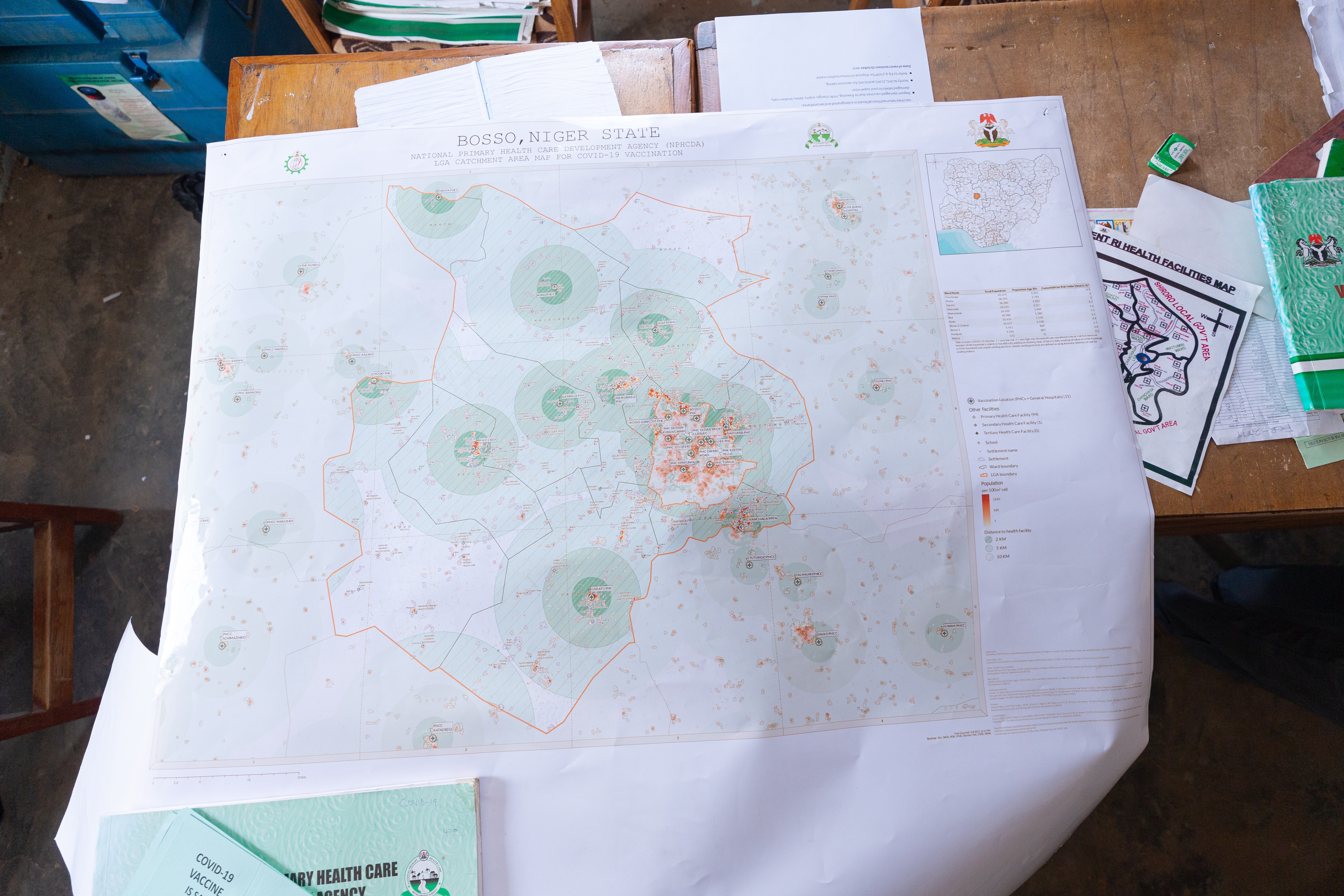
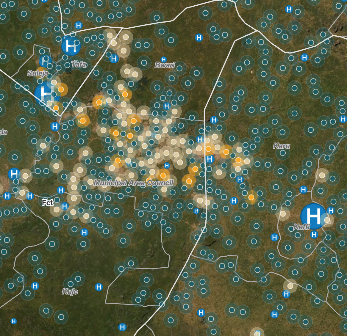
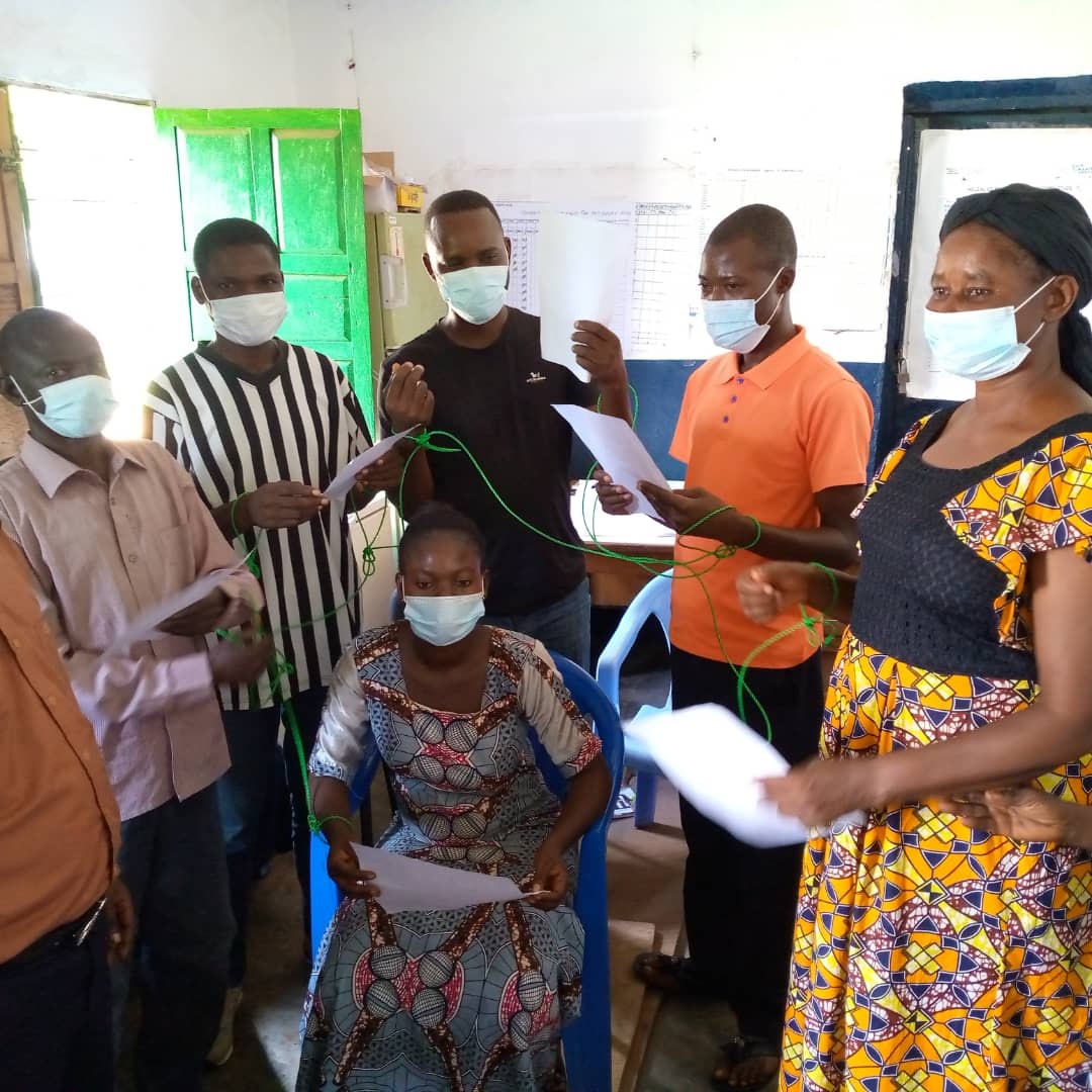
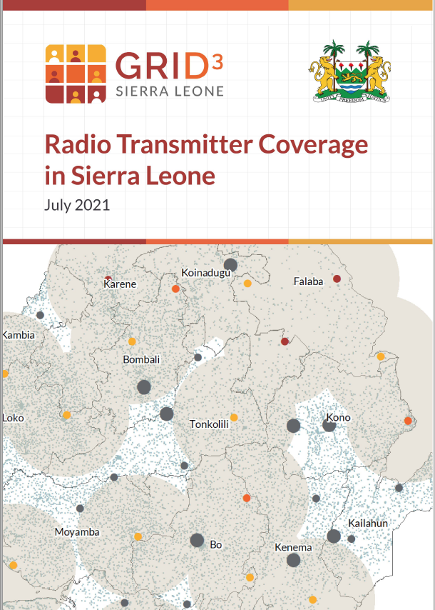
With the onset of the coronavirus disease-2019 (COVID-19) pandemic, public health measures such as physical distancing were recommended to reduce transmission of the virus causing the disease. However, the same approach in all areas, regardless of context, may lead to measures being of limited effectiveness and having unforeseen negative consequences, such as loss of livelihoods and food insecurity. A prerequisite to planning and implementing effective, context-appropriate measures to slow community transmission, is an understanding of any constraints, such as the locations where physical distancing would not be possible.

RESEARCH
High-resolution population estimation using household survey data and building footprints
2022

The national census is an essential data source to support decision-making in many areas of public interest. However, this data may become outdated during the intercensal period, which can stretch up to several decades. In this study, we develop a Bayesian hierarchical model leveraging recent household surveys and building footprints to produce up-to-date population estimates.

Research
Tools for mapping multi-scale settlement patterns of building footprints: An introduction to the R package foot
February 2021

Spatial datasets of building footprint polygons are becoming more widely available and accessible for many areas in the world. These datasets are important inputs for a range of different analyses, such as understanding the development of cities, identifying areas at risk of disasters, and mapping the distribution of populations. The growth of high spatial resolution imagery and computing power is enabling automated procedures to extract and map building footprints for whole countries.

Research
Semi-automatic mapping of pre-census enumeration areas and population sampling frames
2021

Enumeration Areas (EAs) are the operational geographic units for the collection and dissemination of census data and are often used as a national sampling frame for various types of surveys. In many poor or conflict-affected countries, EA demarcations are incomplete, outdated, or missing. Even for countries that are stable and prosperous, creating and updating EAs is one of the most challenging yet essential tasks in the preparation for a national census. Commonly, EAs are created by manually digitising small geographic units on high-resolution satellite imagery or physically walking the boundaries of units, both of which are highly time, cost, and labour intensive.

RESEARCH
Using GIS and Machine Learning to Classify Residential Status of Urban Buildings in Low and Middle Income Settings
November 2020

Utilising satellite images for planning and development is becoming a common practice as computational power and machine learning capabilities expand. In this paper, we explore the use of satellite image derived building footprint data to classify the residential status of urban buildings in low and middle income countries.

Research
National population mapping from sparse survey data: A hierarchical Bayesian modeling framework to account for uncertainty
2020

Population estimates are critical for government services, development projects, and public health campaigns. Such data are typically obtained through a national population and housing census. However, population estimates can quickly become inaccurate in localized areas, particularly where migration or displacement has occurred.

RESEARCH
Classifying settlement types from multi-scale spatial patterns of building footprints
01 May 2020

Urban settlements and urbanised populations continue to grow rapidly and much of this transition is occurring in less developed countries. Remote sensing techniques are now often applied to monitor urbanisation and changes in settlement patterns. In particular, increasing availability of very high resolution imagery (<1 m spatial resolution) and computing power is enabling complete sets of settlement data in the form of building footprints to be extracted from imagery.

RESEARCH
A grid-based sample design framework for household surveys
2020

Traditional sample designs for household surveys are contingent upon the availability of a representative primary sampling frame. This is defined using enumeration units and population counts retrieved from decennial national censuses that can become rapidly inaccurate in highly dynamic demographic settings. To tackle the need for representative sampling frames, we propose an original grid-based sample design framework introducing essential concepts of spatial sampling in household surveys.

RESEARCH
Geospatial variation in measles vaccine coverage through routine and campaign strategies in Nigeria: analysis of recent household surveys
2020

Measles vaccination campaigns are conducted regularly in many low- and middle-income countries to boost measles control efforts and accelerate progress towards elimination. National and sometimes first-level administrative division campaign coverage may be estimated through post-campaign coverage surveys (PCCS). However, these […]

RESEARCH
National and sub-national variation in patterns of febrile case management in sub-Saharan Africa
2018

Given national healthcare coverage gaps, understanding treatment-seeking behaviour for fever is crucial for the management of childhood illness and to reduce deaths. Here, we conduct a modelling study triangulating household survey data for fever in children under the age of […]

RESEARCH
Geospatial mapping of access to timely essential surgery in sub-Saharan Africa
2018

Despite an estimated one-third of the global burden of disease being surgical, only limited estimates of accessibility to surgical treatment in sub-Saharan Africa exist and these remain spatially undefined. Geographical metrics of access to major hospitals were estimated based on […]

Research
Spatially disaggregated population estimates in the absence of national population and housing census data
2018

Population numbers at local levels are fundamental data for many applications, including the delivery and planning of services, election preparation, and response to disasters. In resource-poor settings, recent and reliable demographic data at subnational scales can often be lacking.

Brochure
GRID3 Mapping for Health
March 24, 2021

Supported by Gavi through its INFUSE initiative, GRID3 Mapping for Health in the Democratic Republic of the Congo (DRC) is a Ministry of Health initiative, delivered in partnership with Flowminder and the Center for International Earth Science Information Network at […]

Guidance note
Using GRID3 population data for COVID-19 vaccinations
June 21, 2022

Learn how to use geospatial data to visualise the locations, distribution, and characteristics of vulnerable populations who receive basic health services. These types of visualisations can support efforts to allocate resources and plan outreach activities for COVID-19 vaccination campaigns. They can also be used to inform planning for other health service delivery.

Guidance note
Developing COVID-19 vaccination strategies with GRID3 maps
June 17, 2022

In this guide, we provide instructions on how to use GRID3 maps for COVID-19 vaccination microplanning. We also highlight how comprehensive data on settlement locations, health facilities, boundaries, and target populations (disaggregated by age and travel distance to health facilities) can be used to help answer important questions during planning of a health campaign.

Guidance note
Modelling optimal site placement for COVID-19 vaccination
June 17, 2022

How far does one need to travel to reach a vaccination site? What could be done to improve access to this service? Can we upgrade existing facilities to improve access to vaccination or do we need to create new fixed or mobile sites in specific areas? Answering such questions is essential to successful immunisation interventions, particularly in the context of the COVID-19 pandemic and governmental efforts to roll out effective vaccination campaigns. 

TOOLKIT
GRID3 Mapping for Health Gender Toolkits [Resources in French]
February 24, 2022

As part of the GRID3 Mapping for Health project, Flowminder has released a set of gender toolkits to help tackle gender barriers to vaccination in DRC.

CASE STUDY
Microplanning: A promising approach to identify and reach zero-dose children in Democratic Republic of Congo (DRC)
2023

This case study examines microplanning approaches as a key component in the Mashako Plan 2.0 to revitalize routine immunization strategies in the Democratic Republic of Congo (DRC).

REPORT
GRID3 Impact Report 2017-2022
August 2023

This impact report provides an overview of GRID3’s activities and successes during the program’s first phase, between 2017 and 2022. It highlights key milestones, achievements, and selected use cases from the Democratic Republic of the Congo, Nigeria, and Zambia. The […]

REPORT
Core Spatial Data for sub-Saharan Africa: A report on key spatial data available for development practitioners
September 2021

This report provides an overview of selected core spatial data that are available and accessible in multiple sub-Saharan African countries. The report lists these datasets and their metadata. This report will not recommend a single dataset as being superior to […]

REPORT
Radio Transmitter Coverage in Sierra Leone
July 2021

This project is part of a continued collaboration between Sierra Leone’s Ministry of Basic and Senior Secondary Education (MBSSE, referred henceforth as “the ministry”) and GRID3. Identifying gaps in Frequency Modulated coverage is the concern of the ministry and this report, along with recommendations for how these gaps might best be filled in line with the ministry’s Policy on Radical Inclusion in Schools.

REPORT
COVID-19: Supporting the Government of Namibia with mobility data
December 2020

Anonymised and aggregated data from Mobile Network Operators is a key data source for understanding the mobility patterns of populations, and improving decision-making and scenario planning during the COVID-19 epidemic. This data can be analysed in near real-time and provide an overview of mobility patterns across all of Namibia

REPORT
COVID-19: Supporting the Government of Sierra Leone with mobility data
December 2020

Anonymised and aggregated data from Mobile Network Operators is a key data source for understanding the mobility patterns of populations, and improving decision-making and scenario planning during the COVID-19 epidemic. This data can be analysed in near real-time and provide an overview of mobility patterns across all of Sierra Leone.

REPORT
Education Coverage in Sierra Leone
January 6, 2021

The Ministry of Basic and Senior Secondary Education (MBSSE, referred henceforth as “the ministry”)
is interested in identifying suitable school catchment areas across Sierra Leone (SLE) and publishing
a companion strategy for school development. This report outlines the findings from a preliminary school mapping and coverage analysis whose aim is to provide insights into existing school coverage using the population estimates created jointly by Statistics Sierra Leone and GRID3 (WorldPop and Statistics Sierra Leone, 2020) and the existing school locations from the 2019 Annual School Census (MBSSE, 2019).

WHITE PAPER
Harmoniser les limites infranationales
October 13, 2022

Analyse du travail de GRID3 pour soutenir l’harmonisation, la production et l’utilisation d’unités juridiques/administratives numérisées, opérationnelles et spatiales statistiques. Cette étude se concentre sur des cas étudiés au Nigéria, en République Démocratique du Congo et en Zambie.

WHITE PAPER
Cartographier et Classer les localités
October 13, 2022

Analyse du travail de GRID3 pour collecter et analyser les données des localités. Ce travail se concentre sur deux pôles primaires: créer une couche des localités améliorée et exhaustive qui permet d’avoir une vue d’ensemble des communautés; utiliser les empreintes des bâtiments, les données géospatiales et algorithmes avec apprentissage automatique, pour classer les structures et zones locales au sein des localités. Cette étude explore les applications des méthodes de GRID3 au Nigéria, en République Démocratique du Congo et en Zambie.

WHITE PAPER
Generating and Evaluating Digitised Census Enumeration Areas
2022

Discusses GRID3’s support of countries’ efforts to create and/or strengthen their enumeration area boundaries. The paper focuses on case studies in the Democratic Republic of Congo, Ghana and Zambia.

WHITE PAPER
Mapping Health Facilities
August 23, 2021

Discusses GRID3’s work with local stakeholders and data collectors to build capacity for the production and management of geospatial data on health facilities. This paper focuses on case studies in Nigeria, the Democratic Republic of Congo, Zambia, and Sierra Leone.

WHITE PAPER
Harmonising Subnational Boundaries
September 8, 2020

Discusses GRID3’s work to support the harmonisation, production, and use of digitised legal/administrative units, operational units, and statistical areas. The paper focuses on case studies in Nigeria, the Democratic Republic of Congo, and Zambia.

WHITE PAPER
Mapping and Classifying Settlement Locations
April 8, 2020

Discusses GRID3’s work on collecting and analysing settlements data. GRID3’s settlements work has two areas of focus: creating a comprehensive settlement layer that enables a real-world picture of communities, and using building footprints, geospatial data layers, and machine learning algorithms to classify structures and local areas within settlements. The paper also discusses the applications of GRID3’s methods in Nigeria, the Democratic Republic of the Congo, and Zambia.