GRID3 data to support implementation of Sierra Leone’s Community Health Worker Policy
Sierra Leone’s Directorate of Policy Planning and Information (DPPI), under the Ministry of Health and Sanitation, is working with GRID3 to map settlements where newly trained community health workers will be stationed. The deployment of these workers is part of Sierra Leone’s extended community health policy programme which aims to deliver preventive, promotive, and basic curative services (especially in areas of maternal, child, and nutritional health).
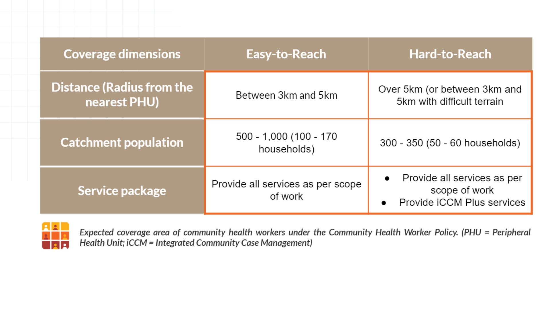
Under the policy, each community health worker is expected to serve a given catchment area determined by population and distance (including road and/or terrain access challenges) from the nearest peripheral health unit to each community.
Spatial data as a building block for effective implementation
Accurate geospatial data, especially settlement data, can help determine challenges community health workers face in service delivery (e.g. barriers to movement, distance of health facilities from communities, households/settlements that are too remote, etc.); DDPI’s hopes to use this information to improve its capacity to deploy health workers.
GRID3 is participating in a geospatial working group that is led by DPPI and tasked with developing digital maps of all settlements; these maps include important infrastructure, such as health facilities. The group also includes representatives of Statistics Sierra Leone, the Directorate of Primary Health Care, the Directorate of Health Services and Emergencies, Macro-Eyes, University of Sierra Leone, UNICEF, and the University of Geneva.
GRID3 gathered existing settlement point data (including census cartography data, health facility data, school census data, and water point data) from the Ministry of Health and Sanitation, Statistics Sierra Leone, the Ministry of Basic and Senior Secondary Education, the Ministry of Water Resources, OpenStreetMap, UNICEF, Hellen Keller, Concern International, WHO, and the Institute for Governance Reform. Records of community health workers provided by the Ministry (and de-identified to exclude names and other personal data) were then matched by GRID3 to the geographic coordinates of those settlement point data. This step made it easier to visualise the current distribution of community health workers and where additional data need to be collected in order to completely georeference the community health worker dataset.
Results from the data matching indicate around 60% of settlements were matched with community health workers, meaning their geocoordinates can be found through existing datasets. For the remaining 40%, community health workers will use a mobile application to collect the coordinates for these settlements. GRID3, in collaboration with Premise and members of DPPI’s geospatial working group, will support the consolidation, cleaning, and standardisation of newly collected data, resulting in a comprehensive dataset of placenames highlighting where community health workers in Sierra Leone operate.
Once completed, the national dataset will be used by the Ministry to assess the current distribution of community health workers around the country, identify areas that may be underserved, and use the findings to inform future programming including resource distribution. This may include the strategic recruitment of additional community health workers and optimal placement of outreach services.
A comprehensive breakdown of GRID3’s settlement mapping approach can be found here.
Featured photo credit: UK Aid, Flickr

