African governments utilise GRID3 data in response to COVID-19
As the outbreak of the new coronavirus begins to extend into sub-Saharan Africa, GRID3 is marshalling its data resources and capacities to help partner governments plan rapid, effective responses.
In Zambia, GRID3 is working closely with the National Spatial Data Infrastructure (NSDI) Technical Committee, a multisectoral group of government officers that includes geographic information systems specialists. In consultation with various ministries and in line with Zambia’s COVID-19 National Multi-sectoral Contingency and Response Plan, the technical committee will be assisting the country’s Emergency Operations Centre, (hosted by the Disaster Management and Mitigation Unit (DMMU), under the Office of the Vice President) to integrate GRID3’s high resolution geospatial data into the outbreak information that is already being collected. This integration will facilitate the visualisation of COVID-19 hotspot areas, the underlying populations in these areas, and the locations of quarantine centres and test facilities. Additionally, GRID3 is creating an easily-accessible, user-friendly platform to host these high-resolution datasets; strengthening the capacity of the Zambian government to generate interactive web maps and maintain the new platform; and, more generally, increasing knowledge around how spatial data can be utilised to improve decision-making and response. A formal concept note on the joint NSDI/GRID3 support for the Government of Zambia’s COVID-19 Response has been sent to the DMMU; as GRID3 awaits an official response to the note, it is assisting NSDI officers to develop the capacity they will need to support the Emergency Operations Centre.
At the beginning of April, Nigeria’s Office of the Vice President asked GRID3 to describe how the programme can support the government’s COVID-19 response. GRID3 submitted a note outlining various ways in which it can contribute to action on the outbreak, including: using GRID3’s high-resolution geospatial datasets to facilitate more accurate and informed COVID-19 response decisions; drawing upon GRID3’s diverse technical and user-oriented resources to produce tools and analyses customized to the needs of the government; and utilising GRID3’s partnership with other actors to support building the tools and/or platforms needed by the government. GRID3 is in a position to support disease surveillance (by mapping population movements); infection prevention and control (modelling and mapping populations most at risk to infection and developing population density maps); and case management (helping to optimise placement of new quarantine facilities and/or expansion of existing facilities). All are priorities identified in the Presidential Task Force’s COVID-19 Pandemic Response Plan.
In the Democratic Republic of the Congo (DRC), GRID3 has been working alongside Bluesquare and PATH to support the efforts of the ANICiiS (a new national agency for clinical information and health informatics) in responding to COVID-19. As a part of that effort, GRID3 is helping to gather and consolidate the latest and most accurate health facility, health boundary, and settlement layers. GRID3 is also generating population estimates to overlay with available infrastructure information, based on its recent population estimate modelling for five provinces and UN-adjusted population estimates for the whole country.
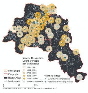
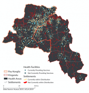
Application: Improving Health Service Delivery in Kwilu, Democratic Republic of the Congo (DRC)
Utilising settlement extents and population grids, it is possible to observe and quantify the settlements and populations beyond health centres’ catchment areas. With this information, mobile health posts can be adequately positioned and planned for effective coverage.
These national-level efforts are part of a broader GRID3 drive to reorganise and scale-up its existing resources (as well as acquire new resources) to support COVID-19 response in sub-Saharan Africa. For example, many countries in the region currently lack maps that include settlement extents, a key planning tool for health policymakers. To address this shortfall, GRID3 had already gathered data on extents in 12 countries. That effort is being expanded now to support policymakers planning COVID-19 responses, and by the end of May extent data will have been produced for an additional 25 countries. (Click here to view existing extents.) GRID3 is also working to create a “critical core” set of spatial data layers so that the response can fully take into account the relationship among people, settlements, subnational administrative units, and health facilities. GRID3 convened a team that includes Esri and Fraym to rapidly build data systems around this critical core set in many countries. This partnership is engaging individual ministries to assist with their COVID-19 responses; assisting with data platform needs by implementing readily-available technology (such as the ArcGIS Hub); assisting with spatial data needs by advising and helping to secure existing data for decision-making (as well as generating new data); and supporting decision-making via relevant data visualisations, customised maps, and data aggregations.
GRID3 will continue to monitor the situation closely, and will release more information about its COVID-19 activities as they develop.
