Taking on COVID-19 with data: Nigeria’s government collaborates with GRID3 on response and prevention
As of 23 June 2020, Nigeria had 13,285 active COVID-19 cases, bringing the total of confirmed cases in the country to 20,919. The first case was registered in the country on 27 February 2020 in Lagos State. Since then, the Nigeria Center for Disease Control (NCDC) has been informing the public on a big scale, providing advisory guidelines on hygiene measures and informing about the importance of practicing physical distancing. In addition to raising awareness among its citizens, the Federal Government enacted mobility restrictions, including a ban of all international flights and a lockdown of non-essential activities in the Federal Capital Territory, and in Lagos and Ogun States. About a month later, the government announced the ease of lockdown measures while enforcing additional preventive measures such as the prohibition of gatherings of more than 20 people outside a workplace and physical distancing of two metres between people in public areas.
The quick and effective reaction of the Government of Nigeria is underpinned by a National COVID-19 Multi-Sectoral Pandemic Response Plan, which presents the country’s actions to slow down the spread of the virus and control the pandemic. GRID3 Nigeria has been working closely with the Presidential Task Force to swiftly support the government’s efforts and integrate geospatial data solutions into their plans.
The GRID3 Nigeria team met with Dr. Mukhtar Muhammad, Incident Manager, National COVID-19 Response Centre of the Presidential Task Force, at the Presidential Villa in Abuja, to discuss how the GRID3 Nigeria geospatial data can be leveraged to support the country’s response against COVID-19, and present an overview of the work taken place to date. Shortly after, the GRID3 Nigeria team, led by Minister of State, Finance, Budget and National Planning Prince Clem Ikanade Agba, met with the Executive Governor of Lagos State, Babajide Sanwo-Olu, and his team to discuss how GRID3 geospatial data can support Lagos State specifically.
Mapping elements of risks
Using geo-tagged household survey data and geospatial covariates (satellite imagery and related derived data products including settlement data), GRID3 Nigeria, through its collaboration with Fraym, is modelling risk analysis across the country. This analysis, presented in the form of maps, covers risks related to exposure, health facility access, communications access, socio-economic vulnerability and comorbidities. These datasets can help decision makers understand likely spread and severity of the outbreak and inform response planning, either directly related to COVID-19 (e.g. disease surveillance) or potential side effects (e.g. maps of likely food security and other humanitarian risks). In addition, these resources provide local insight on how to disseminate public health information and better direct resources and behaviour change messages. All these will enable federal and state governments to deploy the most appropriate resources in the short and medium term for the wellbeing of all Nigerians.
Understanding and measuring the socio-economic impact of COVID-19
While the risk of economic paralysis is increasing, certain populations are more vulnerable during restriction measures, mostly based on their socioeconomic status. From national lockdown to physical distancing regulations, the informal sector, which contributed to 65% of the country’s GDP in 2017, has been particularly hit by the crisis. As part of its risk analysis, GRID3 Nigeria was invited to join the Presidential Task Force’s Socio-Economic Working Group to inform on the socioeconomic impact of the outbreak across the country, at national and state levels. This analysis estimates the vulnerability of poor populations with limited options to cope with economic shocks. It focuses on socio-economic status, housing type, food security, financial inclusion and domestic violence and helps identify the most vulnerable populations.
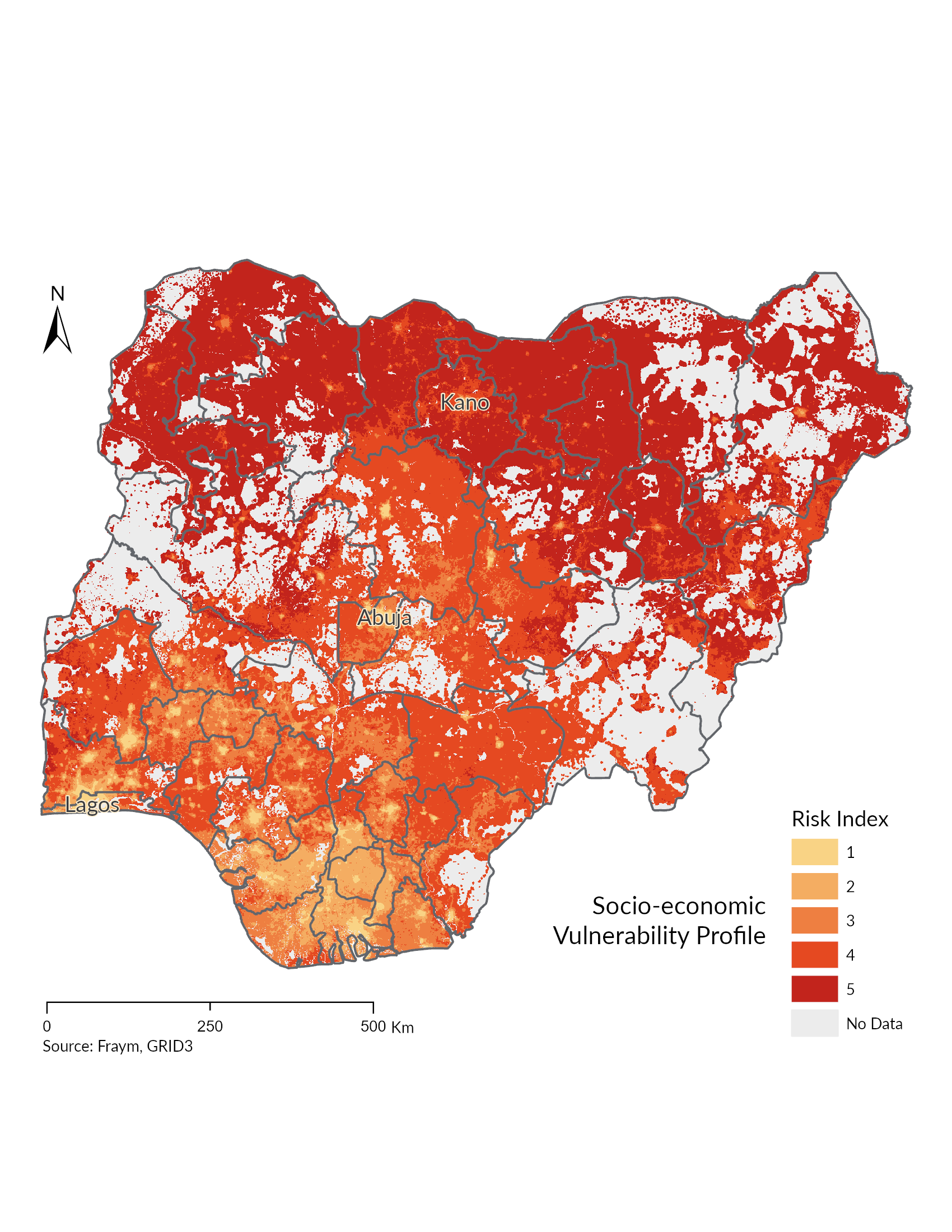
This map of Nigeria shows states at the different risk levels of socio-economic vulnerability ranked from 1 to 5, spread across the country. This indicates that most parts of the northwest fall under high risk (5) compared to states in south-south falling under low risk and medium-low risk (1 and 2) respectively.
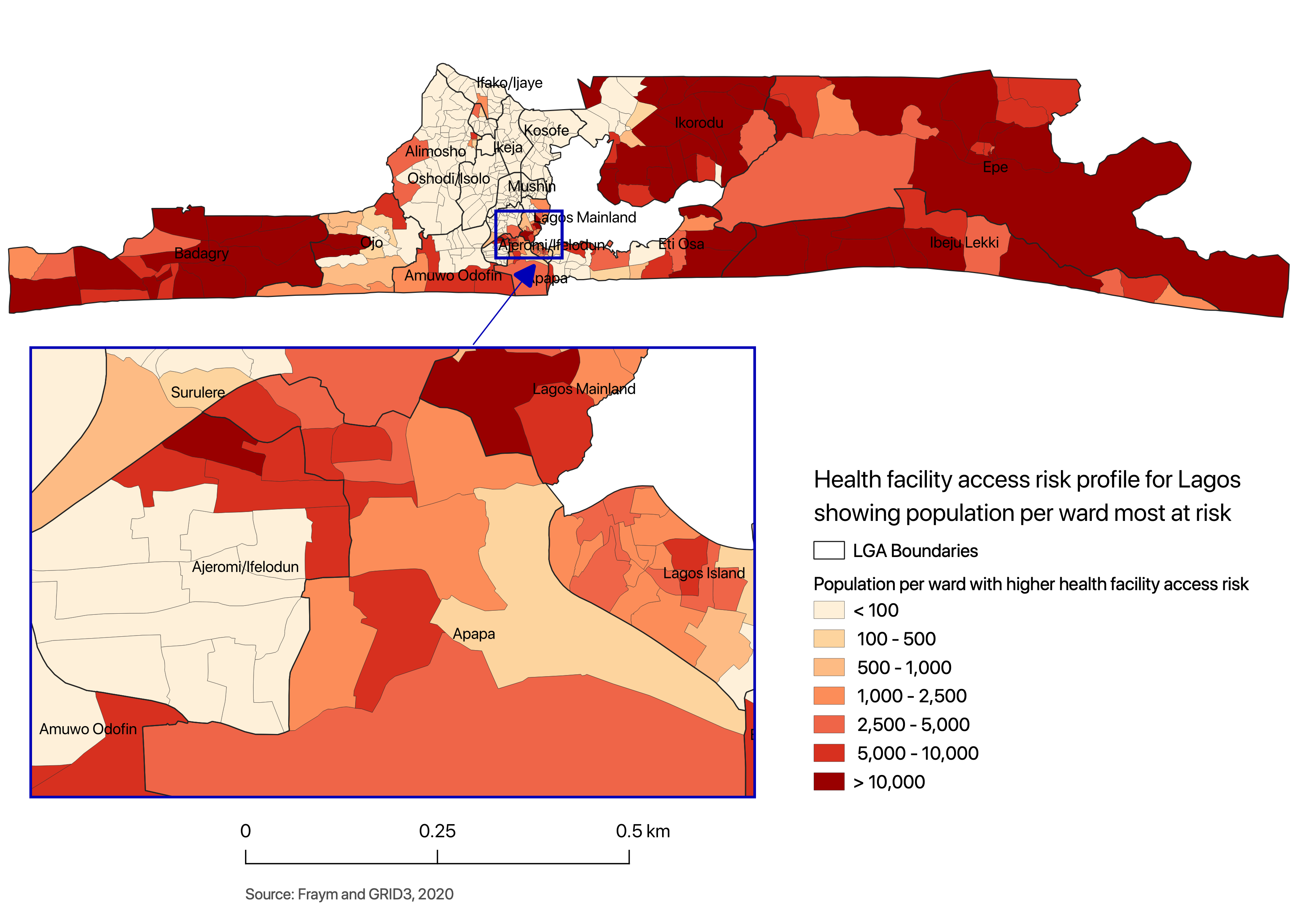
This map of Lagos State shows the population per ward with higher socio-economic vulnerability classified as risk level 5.
Mapping Vulnerable Populations
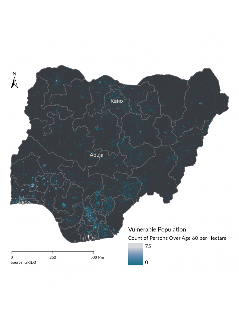
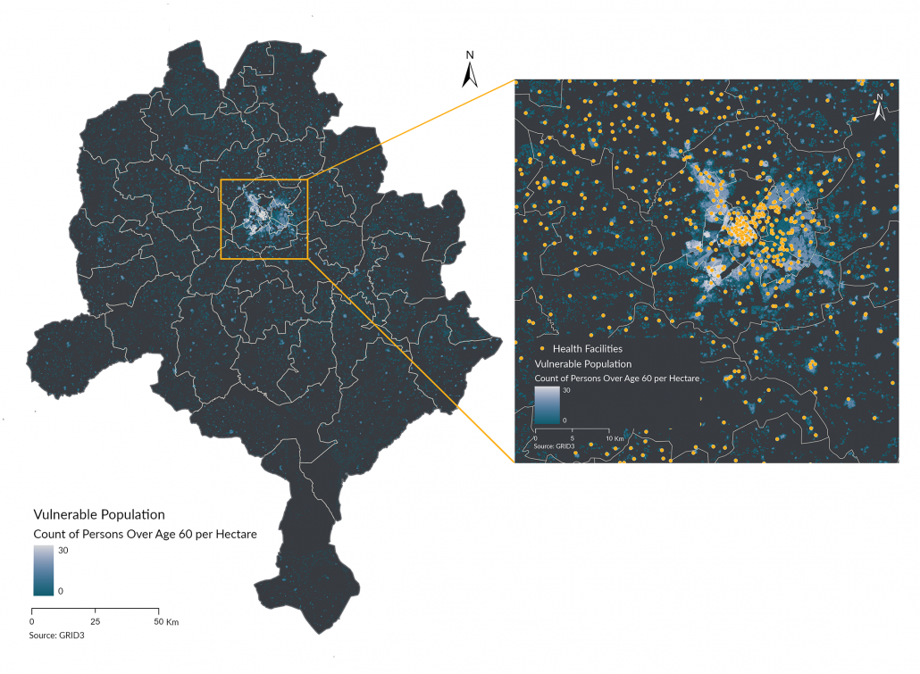
GRID3 Nigeria has previously produced and made available high-resolution gridded population estimates for the whole country (see here). These estimates provide a comprehensive picture of where people live, broken down by age and sex, at a 100 x 100m resolution. This dataset has been utilised to produce maps highlighting areas with populations most vulnerable to the virus by employing data on age groups and population distribution. In addition, GRID3 Nigeria combined these estimates with health facility locations to measure geographical access to health facilities – this can be illustrated with the following two examples:
Both maps display the population of Nigeria above 60 years old, at national scale (left) and for Kano state (right). This is particularly important for intervention planning as older persons have been identified as being at risk of potentially suffering from more severe consequences of a COVID-19 infection. For Kano, the team overlaid gridded population estimates for this population group with health facility locations, to evaluate access and distance to health services. Information of this type will support presidential and state task force teams in planning their interventions through a better understanding of the population distribution.
Enhancing data applications at national and state levels
To facilitate data access and collaboration and enable visualisation and analysis of various COVID-19 indicators, the Nigerian National Bureau of Statistics, in partnership with GRID3, Esri and Fraym published a COVID-19 data hub. This platform aims to serve as a repository for all COVID-19 related digital resources in Nigeria to aid response efforts across the country.
Taking on COVID-19 with data
The integration of geospatial data into presidential and state task forces’ plans will support the achievement of Nigeria’s National COVID-19 Multi-Sectoral Pandemic Response Plan and enable a targeted response nationally and across states. Knowing where people live and what level of healthcare services are available in any given area can help decision makers in Nigeria determine the most suitable strategies in responding to the COVID-19 pandemic. While GRID3 has been shifting resources to help stop the spread of the virus, the team is still working closely with the National and Steering Committees to support the country in achieving its national development goals, including, among others, guaranteeing access to education for all.
