Nigeria’s young data science talents seize new geospatial data opportunities
Data Science Nigeria (DSN) and GRID3 Nigeria share a common goal: increasing the number of geospatial data experts across the country to support Nigeria’s national development agenda. For the second year in a row, GRID3 was invited to attend DSN’s 2020 Artificial Intelligence (AI) Bootcamp for a series of workshops focused on geospatial data analysis, tools and applications. Held online due to COVID-19, the bootcamp’s 250 finalists learned the principles of Geographic Information Systems (GIS); familiarised themselves with QGIS, an open-source GIS software; and put into practice their analytic and visualisation skills through a series of demonstrations and activities.
Three workshops around geospatial data analytics
To ensure finalists understood how geospatial data can add value to decision making for humanitarian and development purposes, sessions were organised to cover both theory and practical activities, with a strong emphasis on actual data applications. Practical exercises included the production of a QGIS analysis proposing locations for mobile vaccination posts, in areas which the data suggests could be under-resourced, in the event of a disease epidemic scenario, as well as a R demo to assess coverage of schools using GRID3 population estimates for education planning in Lagos.
“In GRID3’s workshops, we don’t solely focus on the theoretical aspects of GIS. Interactions through Q&As, games, and practical exercises form an integral part of our pedagogy,” says Wole Ademola Adewole, Implementation Coordinator for GRID3 Nigeria.
“One of our sessions solely focused on data applications so that learners could see the broad range of opportunities geospatial data provide and start imagining solutions to development or humanitarian challenges in their communities.”
GRID3 Nigeria Data Challenge: running analyses that can solve issues related to food security, health, finance, and transportation in Lagos
To further enrich participants’ experience, GRID3 launched its Data Challenge for its second year (read about last year’s challenge here). The challenge is a competition wherein participants submit innovative ideas around the use of geospatial data in Nigeria.
Challenge participants had a month to produce a geospatial analysis proffering a solution to a problem identified in one of four sectors: agriculture/food security, health, finance, and transportation in Lagos (these were chosen to align with the national priorities identified by GRID3 Nigeria’s National Steering Committee, led by the Ministry of Finance, Budget and National Planning, and current GRID3 engagements and activities). The competition aimed to highlight how geospatial data analytics can support the national development agenda, as well as generate ideas around the use of geospatial data.
Out of the pool of applicants, two winners were selected based on the following criteria: methodology, the expected impact of proposed solution, and uniqueness. All participants received feedback on their work, while the two winners (Akinyiga Obadamilare. D. and Mmuokuba Michael Chiemerie) were given in-depth feedback on their analyses by GRID3 GIS experts, as well as invited to join the GRID3 Nigeria Community of Practice. This community brings together, across Nigeria, like-minded geospatial data users to discuss GRID3 data use and continuously develop their skills through shared experiences, facilitated sessions, and best practices.
What Akinyiga Obadamilare. D. and Mmuokuba Michael Chiemerie learned from using geospatial data for good
-
 Akinyiga Obadamilare. D.
 -
 Mmuokuba Michael Chiemerie
Akinyiga Obadamilare. D. and Mmuokuba Michael Chiemerie might be new to geospatial analysis, but they rank among some of the best young AI talents in Nigeria; like all participants, both had to complete a rigorous selection process in order to be admitted.
“I discovered Data Science Nigeria and how AI can transform health, marketing, and business back in a local event in 2019. That’s when I told myself I needed to make it to the Bootcamp. I participated in the 2019 programme and GRID3 sessions and took part in the Data Challenge back then. I did not make it to the top two last year, but it motivated me to learn even more about R for geospatial analysis and GRID3 datasets, which led me to where I am today.”
Akinyiga Obadamilare. D.
“I am grateful for having joined the Bootcamp and GRID3 sessions. They changed my mentality and the view of data science for good. Through the GRID3 sessions, I was able to not only develop new skills, but also shape my personal and career paths, and consider how I can use GIS and machine learning models to create projects that solve development challenges in my country.”
Mmuokuba Michael Chiemerie
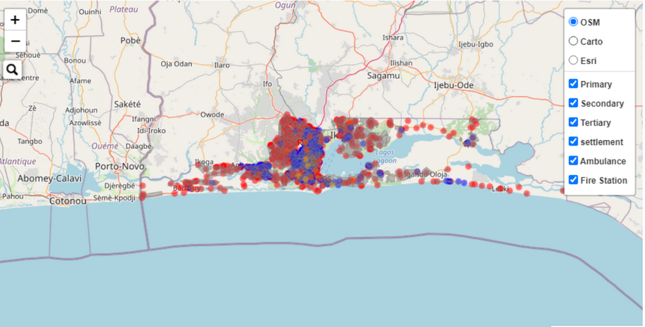
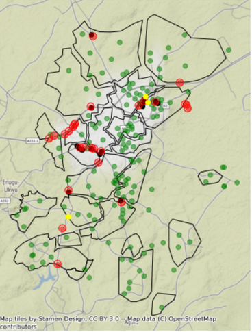
While Akinyiga analysed the positioning of emergency centres relative to health care centres in Lagos, focusing on a fire outbreak case study, Michael C looked into managing the risk posed by fire outbreaks in gas plant/filling stations to nearby residences. Though neither had much experience with practicalities of their chosen challenges, both took on the challenge of thoroughly researching the problem and imagining a solution using GRID3 and other geospatial datasets. Through this work, they discovered the multitude of analyses and applications that GIS provides.
“Geospatial data is the bedrock of solving most of the problems we have in the country. Handling different data types played a huge role in giving me more insights into my city.”
Akinyiga
Left map: Using R programme, Akinyiga developed a solution which maps out the locations of health centres in categories, emergency centres, and settlements
Right map: With this map, Michael C visualised settlement points to understand the service coverage of fire stations in cluster locations of filling stations (red: filling stations; yellow: fire stations; green: settlements points).
Working with multiple geospatial datasets, Akinyiga fostered his understanding of how emergencies and disasters can be managed in Nigeria. His analysis improved his understanding of the geographic position of health centres that can handle emergencies and how close the emergency centres are to health centres. Michael C’s analysis determined better locations for oil and gas stations (based on existing settlements) in order to reduce the risk of fire outbreaks to nearby inhabitants. While conducting their analysis, GRID3 experts provided extensive feedback on methodology, additional datasets, and visualisation, amongst other issues. This process enabled the two participants to assess and strengthen their current skills. For example, following the challenge, both were able to assess the value of road network data and gridded population estimates, allowing them to refine their analysis.
“We don’t expect delegates to become GIS experts within a month. Our goal through the Data Challenge is to spark interest in geospatial data and provide participants with a better understanding of the wide range of solutions available through GIS, so they can build from their work and take it to the next level”, says Wole Ademola Adewole.
GRID3 Nigeria is committed to building a community of practice where data experts and enthusiasts across the country learn to utilise GRID3 data to solve development challenges. Through their partnership, DSN and GRID3 are reaching a wide, diverse audience.
“Taking part in GRID3 sessions will expose you to using geospatial data to solve problems that real world data can not necessarily solve. This is of benefit to any aspiring data scientist who wants to use any kind of data to solve challenges.”
Mmuokuba Michael Chiemerie
“I will encourage you, if you have the opportunity to make it to the Bootcamp, to attend the GRID3 session. It is the opportunity of a lifetime to be able to talk with experts in the field from across the world. You have the chance to discuss problems and at the same time work through hands-on, nation-based problem sessions.”
Akinyiga Obadamilare. D.
