GRID3 maps to improve mobile health service delivery in the Somali and Afar regions of Ethiopia
Amref Health Africa is in the middle of planning the equitable placement of mobile health services for the Somali and Afar regions of Ethiopia. The NGO aims to ensure lasting changes to healthcare access in Africa’s second most populous country. Due to regional instability, staff have had difficulty in obtaining up-to-date demographic and infrastructure data to help with the placement of new mobile outreach service sites.
Derebe Tadesse, Monitoring & Evaluation Director at Amref Health Africa, explains the lack of geospatial demographic and infrastructure data is also due to changing population movements:
“A majority of the population in the Somali and Afar regions are pastoralists who frequently move in search of food and water resources. Because there are constant movements, it has been difficult for us to accurately assess where people live in relation to health facilities. As a result, we looked into other ways we could obtain this information to aid our planning.”
After learning of GRID3’s infrastructure mapping work, Amref Health Africa met with the GRID3 Ethiopia team to see how the programme could best support its mobile health service delivery planning through health facility mapping. Using set parameters from Amref Health Africa, GRID3 created 133 maps showcasing how far people live from health facilities and the size of those populations for all districts (called woredas) in the Somali and Afar regions. Amref Health Africa will be using the maps to identify where mobile health/outreach services are most needed.
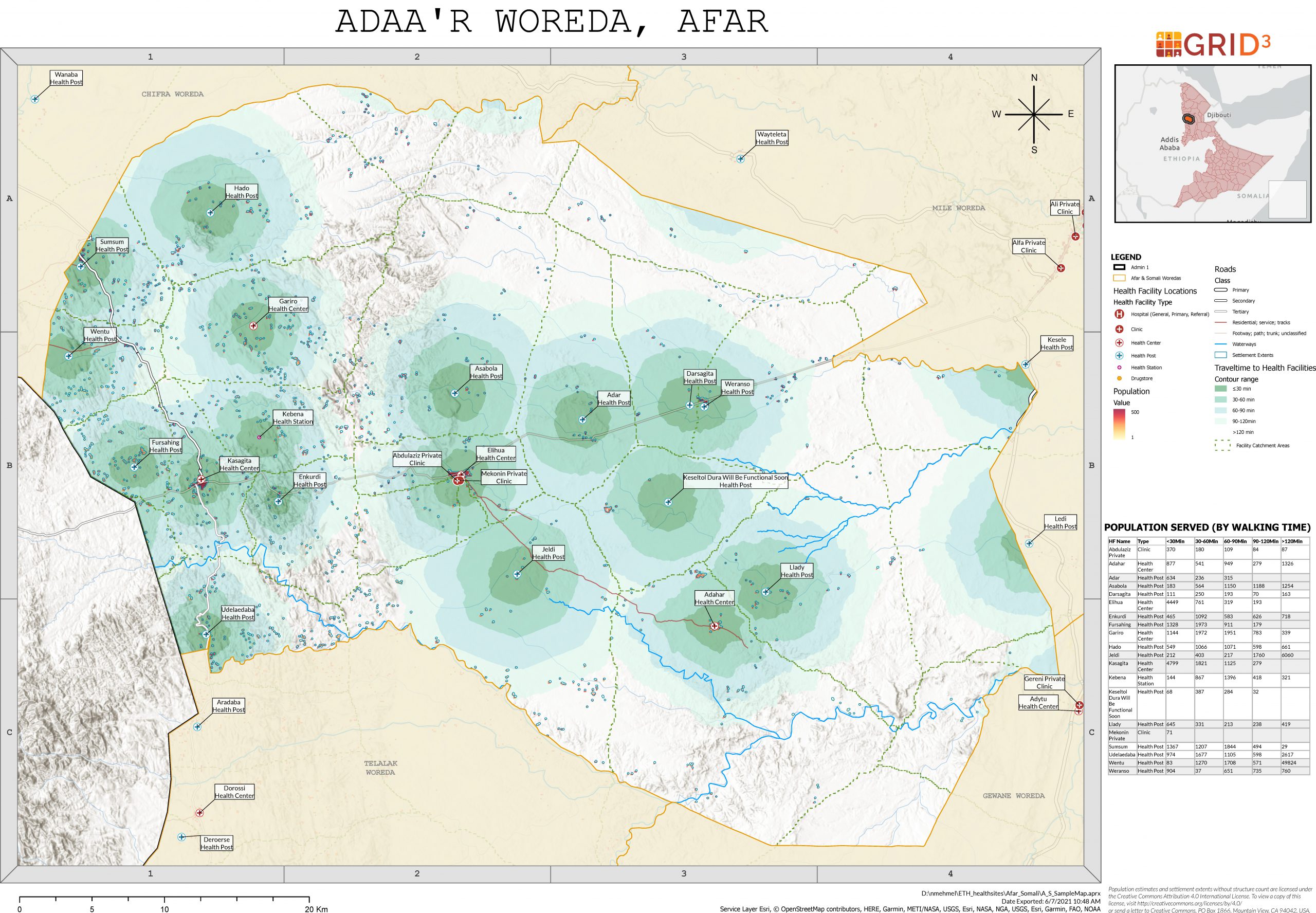
Sample map from Adaa’r Woreda in Afar Province, Ethiopia.
Each woreda-level map includes relevant administrative boundaries; health facility points symbolised by facility type; facility catchments depicting travel time to each facility by foot; settlements extents; roads and highways; rivers; and population estimates. On the right is a table representing the population served by each facility and the travel time required to get there by foot.
Creating and operationalising the maps
To produce the visualisations, Amref Health Africa collected information on the locations of health posts in the two regions. The GRID3 Ethiopia team then combined these data with other health facility data (featuring point location, facility name and type, and District Health Information Software identifying codes) collected by the Ethiopia Public Health Institute and a variety of NGOs to create a dataset, consolidating information about the location of health facilities.
Subsequently, the GRID3 team used friction surface and travel time scripts they produced to create an accessibility model that calculates the number of people living within 30, 60, 90 and 120-minute walking distance from the nearest health facility based on WorldPop’s UN-adjusted population estimates and the new health facility dataset. A friction surface script predicts the time it would take for a person to cross a 100m grid cell, taking into account “resistance” factors that might affect travel time such as road or footpath accessibility, land cover type when paths are not present, surface elevation and terrain slope, and the presence of physical barriers like rivers and waterways. The travel time script generates contours of 30, 60, 90, and 120-minute walking distance from each facility and catchment boundaries, dividing and directing populations to the nearest health facility based on the shortest available travel time. Friction surface and travel time scripts are written into ArcGIS Online to semi-automate calculations.
“These maps will allow us to determine the locations of our mobile outreach service sites based on where the largest number of people, who live more than a 60-minute walking distance from the nearest health facility, can be found. We are working with our regional teams to review the maps to see where we can include settlement names. Thanks to this information, our decisions will be more informed, increasing the impact of our intervention,” says Tadesse.
In the coming months, Amref Health Africa plans to train staff in using the maps during its annual planning period.
