Supporting vaccination microplanning in Mozambique
With nearly aIl adults vaccinated against COVID-19, Mozambique has made important strides toward protecting communities from the virus’s worst effects. GRID3 provided support in these areas, with a focus on two specific initiatives: mapping communities’ relative risk to COVID-19 and producing microplanning maps that can aid the deployment of resources around vaccination efforts.
COVID-19 risk data
In April 2021, GRID3 received a request to support the National Institute of Health (INS), Ministry of Health (MISAU), and Office of the President in the production of COVID-19 risk data. The project, coordinated by Oxford Policy Management (OPM), sought to combine different data sources on COVID-19 risk factors, improve digital mapping of these factors, and make these data available via a dynamic, interactive online data visualisation tool (a “risk mapper”) that could help officials more effectively allocate resources.
GRID3 coordinated with Fraym, OPM, INS, and the Academic Association of Nutrition and Food Security (ANSA) to identify the available geospatial data sources, identify outstanding data needs, and select priority indicators to be used on the online tool. GRID3 and Fraym then produced a COVID-19 risk mapping data package which included a total of 10 indicators, including ones relating to population density; access to health facilities; water, sanitation, and hygiene; comorbidities; socioeconomic status; education; and access to forms of communications. In September 2021, the data were integrated into the Mozambique Risk Mapper platform that was being developed with INS. The risk data were also published on GRID3’s data hub.
In March 2022, INS, ANSA, and OPM held a workshop session on the Mozambique Risk Mapper for key stakeholders. The session was part of a broader workshop that addressed not only the mapper, but also other online platforms on HIV, mortality, climate and health, women and children’s health, and nutrition. The participants gave positive feedback and suggestions for how to make the mapper more useful.
Microplanning maps
In April 2022, GRID3 (with support from ICAP) began working with stakeholders to produce customised GIS-based maps that can be used for microplanning in Mozambique’s COVID-19 vaccination campaigns, as well as for routine immunisation activities. “Microplanning” refers to the process in which health workers plan how to deploy resources—including mobile brigades, vaccines, and other health-related commodities—to ensure that vulnerable populations are reached during a health intervention.
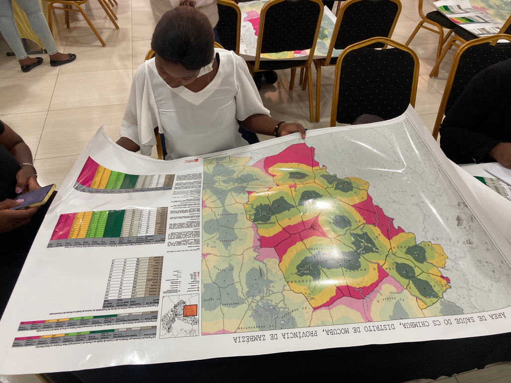
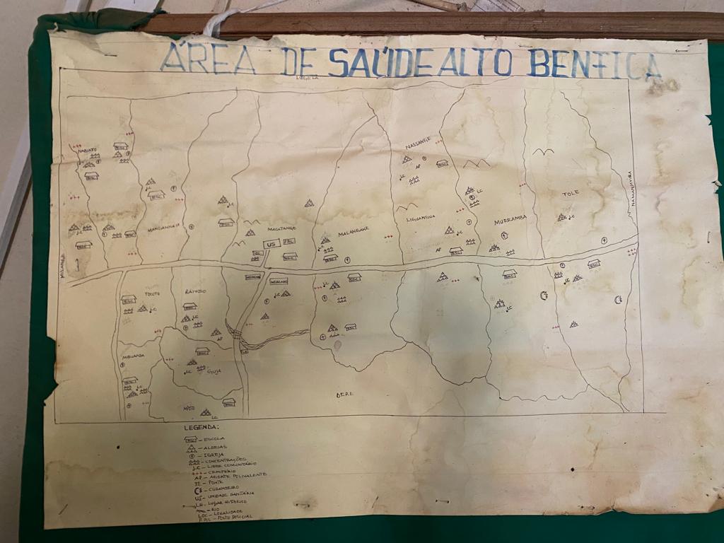
Following a stakeholder analysis and needs assessment involving face-to-face meetings with key stakeholders between April 2022 and October 2022, the country’s Expanded Programme on Immunization (EPI) decided that the second phase of Mozambique’s COVID-19 campaign (held in November 2022) aimed at adolescents (ages 12-17 years) would provide a good opportunity to test microplanning maps based on the data collected and generated for the Guro and Mocuba districts through digital operationalisation efforts for routine immunisation under the Reach Every District (RED) microplanning initiative. This initiative is led by UNICEF in collaboration with the MoH, National Agency for Geospatial Development (ADE), the Clinton Health Access Initiative (CHAI), and the Health GeoLab (HGL). The RED datasets included: the locations of important infrastructure for immunisation services (health centres and concentration points where mobile vaccination units provide services); associated proximity basins (area demarcating the anticipated health service coverage for a single health centre or concentration point); the time it takes populations to reach the nearest health centre or concentration point by foot; district boundaries; and road and hydrographic networks. GRID3 created preliminary district and 21 health area-level maps for Mocuba using RED data and other GRID3 datasets (settlements, population distribution) and presented them to RED partners to obtain feedback. In each round of feedback from partners, GRID3 refined the maps. When the maps were finalised by the partners, GRID3 printed them and had a variety of health professionals review them for accuracy and completeness.
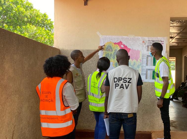
On 12 November, representatives from a variety of institutions including the Ministry of Health, EPI, ADE, CHAI, and GRID3 met for a workshop with the district health team in Mocuba. GRID3 presented the Mocuba district- and subdistrict-level maps together with associated tables. These maps and tables displayed population on target age groups 12-17 years and under 5 years and estimated walking travel times from any point in the district to the nearest health centre or concentration point.
At this workshop, several exercises were held to help participants practice using the maps and tables and to identify any errors that might exist in the maps (i.e. in the data used to make the maps), as well as to validate the data that they found to be accurate.
The meeting was a success; it showed stakeholders potential applications of the GIS-based microplanning maps and tables that had been prepared. Based on the results of an evaluation survey completed by 58 participants in the field, most found the maps and data tables easy to understand and interpret; they reported that their use had a positive impact on the vaccination campaign field activities. The survey respondents provided comments on the quality and completeness of the maps and tables, and made suggestions for improvement.
The Ministry of Health, EPI, and RED/REC technical working group partners (ADE, CHAI, HGL, and GRID3) plan to continue working together to improve available data and maps, looking ahead to upcoming polio, measles, and routine immunisation campaigns.
