GRID3 interactive data visualisation: mapping a path for COVID-19 response
The new GRID3 interactive data visualisation hubs provide a vital, centralised source of high quality geospatial data. They enhance coordination on data production, and encourage closer coordination among the various government bodies that are working on COVID-19 prevention and response. The comprehensive online platforms are conceptualised and created under the leadership of government partners and made possible through partnerships with Esri and Fraym.
In addition to the enormous mortality and morbidity caused by COVID-19, the pandemic also results in extreme economic and social distress. Having access to high resolution geospatial data is of paramount importance during this time, and GRID3 has quickly shifted its priorities to meaningfully leverage its data to support countries’ prevention and relief efforts. To ensure that this data quickly and efficiently reach the communities in need, GRID3 partnered with Esri and Fraym.
In collaboration with national governments, GRID3, Esri, and Fraym are producing user-friendly data hubs that serve as consolidated online repositories for geospatial data. Among other features, the hubs give users access to data visualisations, such as web maps that can show locations of positive cases (or aggregated counts of cases) at the subnational level that are combined with other relevant information like locations of hospitals, isolation centres, population density in the epicentres of COVID-19 infections (or in close proximity to the hot spots). The visualisations can also show the total number of tests that have been registered in a given country, adding an important layer of context for a detailed overview that is as complete as possible.
While the main focus of the data hubs currently centres on COVID-19 relief, the hubs’ usefulness extends far beyond the pandemic. Collaborating with Esri, GRID3 will deploy a Global Data Hub to host the core foundational data products on ArcGIS Online, a technology that enables its users to create interactive maps and online platforms. In addition to ArcGIS Online serving as a data repository where data can be easily accessed for download, the hub website will showcase GRID3 data via interactive visualisation tools, as well as link to the country-specific hubs developed in coordination with government stakeholders.
Finally, GRID3 and Esri will assist countries with building visualisation tools such as dashboards, web applications, and web maps, and are providing technical expertise and capacity strengthening assistance where needed. The data hubs that host the tool suite are highly adaptable to local requirements and can be adjusted over time as priorities evolve.
Nigeria helping to lead the way
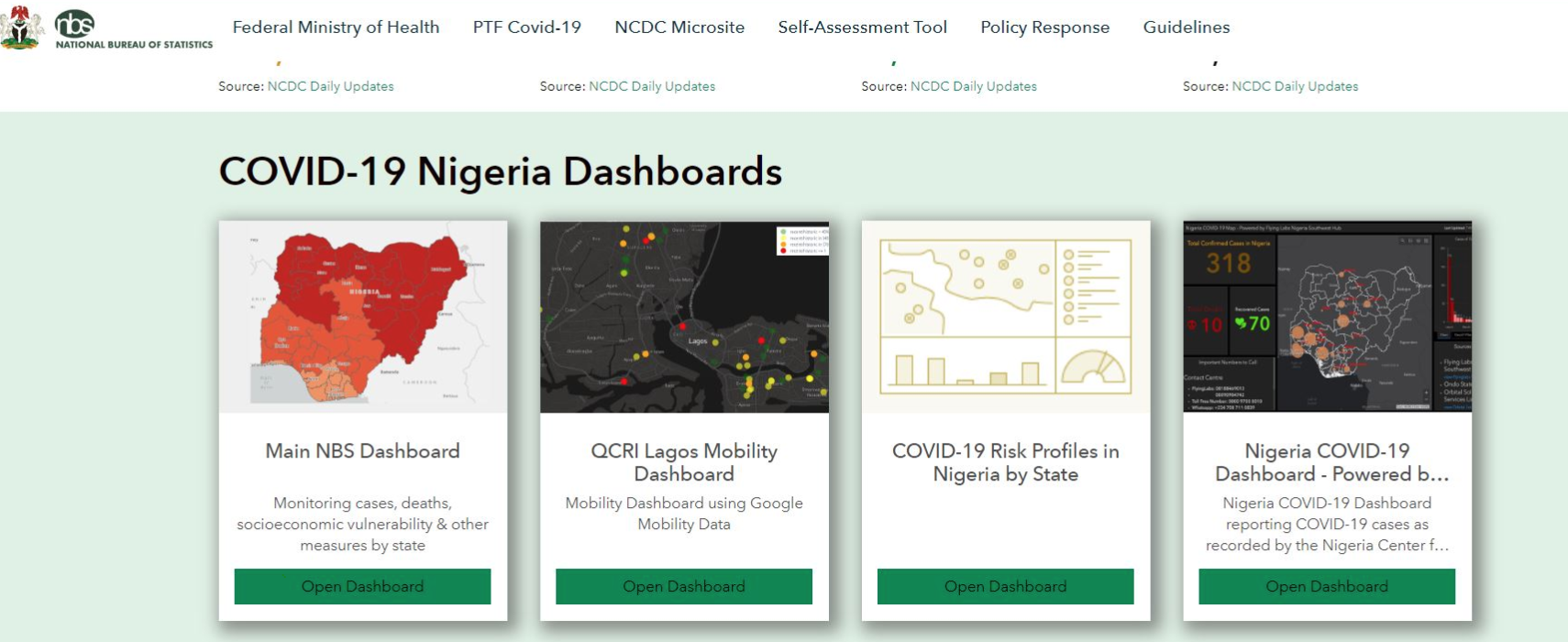
One of the longest-standing and most active partners in the GRID3 programme, the Government of Nigeria has taken on a leading role in the digital visualisation sphere. The country’s COVID-19 data hub, led by the National Bureau of Statistics, serves as a central repository for a wide array of COVID-19 data and visualisations. It combines and centralises data and visualisations from several government agencies, providing decision makers and the general public alike with a go-to source for COVID-19-relevant population data. The hub was launched on 8 June, and is comprised of interactive maps that display a wide range of information, including population estimates with points of interest like healthcare facilities; risks associated with COVID-19, provided by Fraym; comorbidities like tuberculosis and HIV; or changes in mobility by state. Monitoring and addressing secondary COVID-19 impacts on livelihoods is also a priority for the Nigerian government that will enable it to address the pandemic in a socially sustainable way. Additional data and the Nigeria Centre for Disease Control’s COVID-19 dashboard are also available on the Nigeria COVID-19 data hub hosted by the National Bureau of Statistics.

Strengthening capacity in geospatial data with GRID3 (Data Science Nigeria’s AI Bootcamp, November 2019)
Population estimates and more available on Zambia’s hub
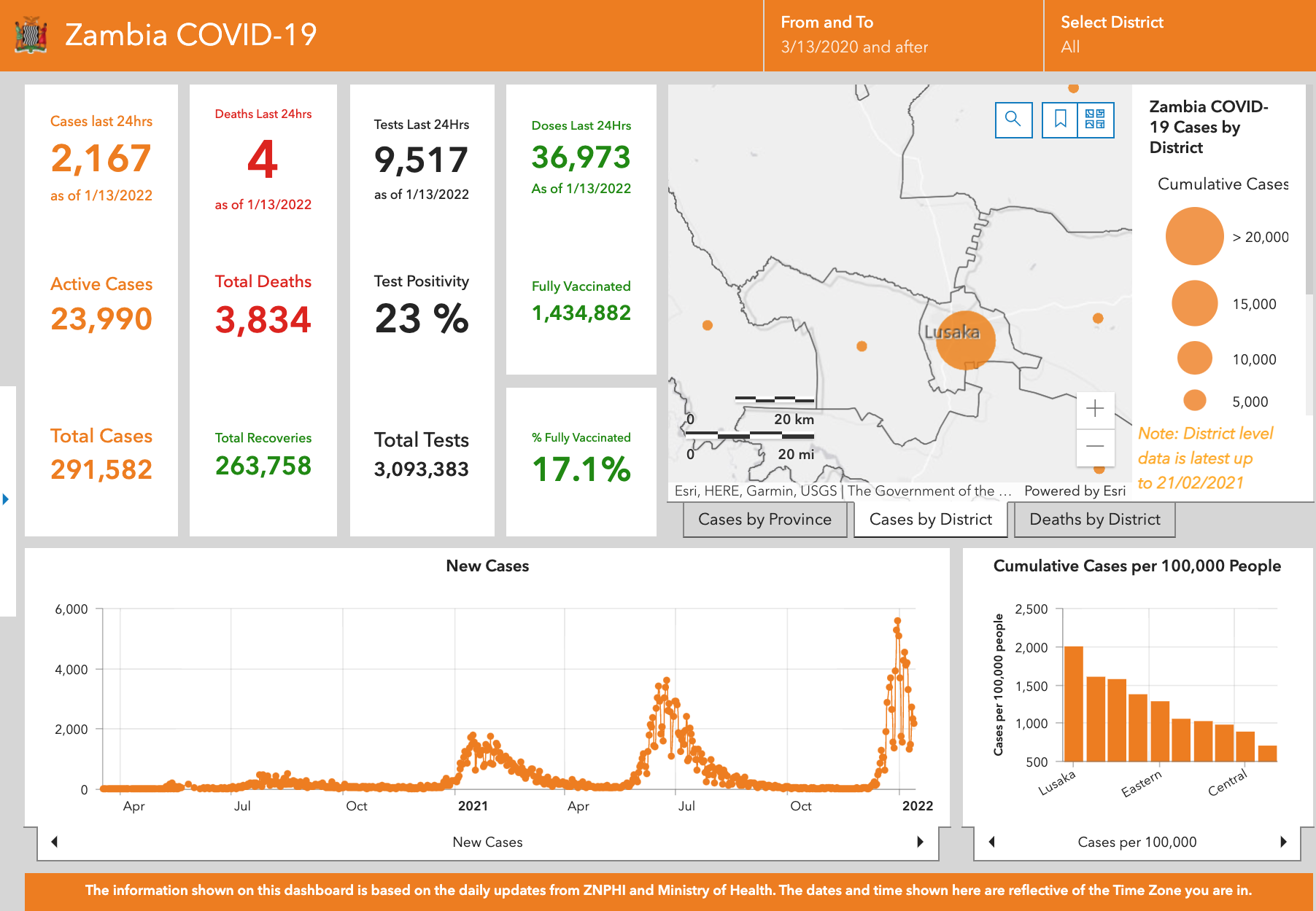
Beginning in the early stages of the pandemic, the GRID3 team consulted with government stakeholders in Zambia about how high resolution data products can help to meet the country’s most urgent COVID-19 needs. A major result of this collaboration is the Zambia COVID-19 hub, published on 18 June. The hub, produced in close collaboration with Esri and government stakeholders, includes a dashboard and interactive maps that utilise GRID3 gridded population estimates, settlement locations, boundaries, and points of interest. The hub also features significant data inputs provided by the Zambia Statistics Agency.
In addition to the core data products, the hub hosts data related to COVID-19 response, such as dashboards featuring population at various risks and interactive web maps showing areas with high population density where physical distancing difficulties are likely and where additional interventions could be needed. GRID3 had been coordinating with the National Spatial Data Infrastructure of Zambia (NSDI) COVID-19 sub-working group to identify needs, train NSDI members, and build capacity on the use of ArcGIS Online to build interactive web platforms.
Taking data to scale
GRID3, Esri, and Fraym are building on the results achieved in Nigeria and Zambia to expand COVID-19 support throughout sub-Saharan Africa. Interactive hubs for Sierra Leone, Namibia, and South Sudan are close to being launched, and efforts are underway to further scale-up open data through hubs that feature dashboards, interactive maps, and other web apps.
“A smart answer to COVID-19 has to be data-driven, timely, and transparent. But it can’t stop there. Together with governments, we want to promote a culture of open geospatial data that goes beyond the pandemic. Jointly developing the data hubs and dashboards and ensuring the capacity for countries to further build on the platforms as the go-to place for geospatial data is our goal; governments are not only embracing this approach, but pushing us to expand the existing partnerships,” says Lorant Czaran, GRID3 programme lead for UNFPA.
The challenges posed by the pandemic are unprecedented, and the best available data must be used to inform prevention and response. GRID3 will continue to strive to meet the data needs of governments and other stakeholders, helping to limit the spread of the virus and save lives.
