Improving geo-referenced microplanning for immunisation interventions in the DRC
Over the course of the last three months, the GRID3 Mapping for Health project carried out extensive stakeholder engagement and field exercises aimed at evaluating the impact of the pilot phase of its geo-referenced microplanning work. These activities are part of a broader push to strengthen the capacity of health actors to use geo-referenced data to inform immunisation planning decisions throughout the country.
The pilot phase
In the DRC, GRID3 Mapping for Health project contributes high-resolution geospatial data and key information related to gender and equity to support the Mashako Plan, a government-led effort to boost routine vaccine coverage.
Working in collaboration with government agencies, the project collected data on the locations of health facilities, towns, villages, and hamlets; boundaries of health zones and areas; the size, density, age, sex structure, and spatial distribution of populations; as well as information on population movements. These datasets were then used to produce a collection of maps and tables for microplanning (microplanning is the process of determining a strategy to optimally deploy resources in order to vaccinate eligible populations).
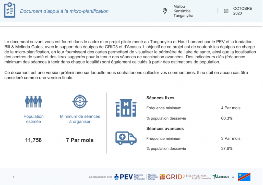
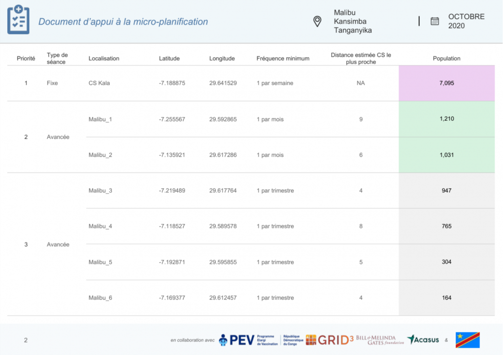
Geo-referenced microplanning maps and tables for Malibu, Tanganyika
Using guidelines from local practitioners, the microplanning maps and tables show the minimum frequency for immunisation sessions required to reach the target population within a 3km radius of each location. The first version of these documents was distributed in 598 health areas, 27 health zones, and 4 health antennas in Haut-Lomami and Tanganyika provinces in March 2021, with the support of the Expanded Programme on Immunisation (EPI) and Acacus. With close supervision by the health zone management, head nurses in these provinces adapted the microplanning maps and tables to create vaccination schedules for their immunisation teams during the pilot.
Monitoring and evaluation field mission
In September, the EPI, WHO, UNICEF, the GRID3 team, and Acasus carried out a field mission to assess the impact of the microplanning maps and tables. Forty-eight immunisation teams across the two pilot provinces were selected for the assessment based on criteria designed to ensure representativeness. Of the head nurses surveyed, 90 percent demonstrated good understanding of the maps and tables based on questions asked by the survey teams, and 85 percent of the surveyed immunisation teams confirmed that they adjusted their vaccination strategies to meet the recommendations provided in the documents.
Overall, health officials in Haut-Lomami and Tanganyika found the recommendations in the support documents to be “very relevant” and requested that the GRID3 Mapping for Health team produce similar documents to help them build more data-driven microplans in the future.
Scaling the impact
In October and November, GRID3, EPI, WHO, and UNICEF convened a series of events targeted at promoting awareness of the microplanning work among health stakeholders. Participants reviewed the results of the pilot phase, provided some recommendations for the final version of the microplanning documents, and suggested ways to sustainably integrate these documents into traditional microplanning processes across other provinces (Haut-Katanga, Kasaï, Kasaï Oriental, Kinshasa, Kwilu, and Lomami).
The Mapping for Health team continues to engage with the Ministry of Health and the National Institute of Statistics to facilitate data integration and sustainability on a national scale while exploring use cases for the support documents in the context of other health programmes being conducted by various stakeholders including the United Nations Office for the Coordination of Humanitarian Affairs, Clinton Health Access Initiative, Action Against Hunger, and many others.
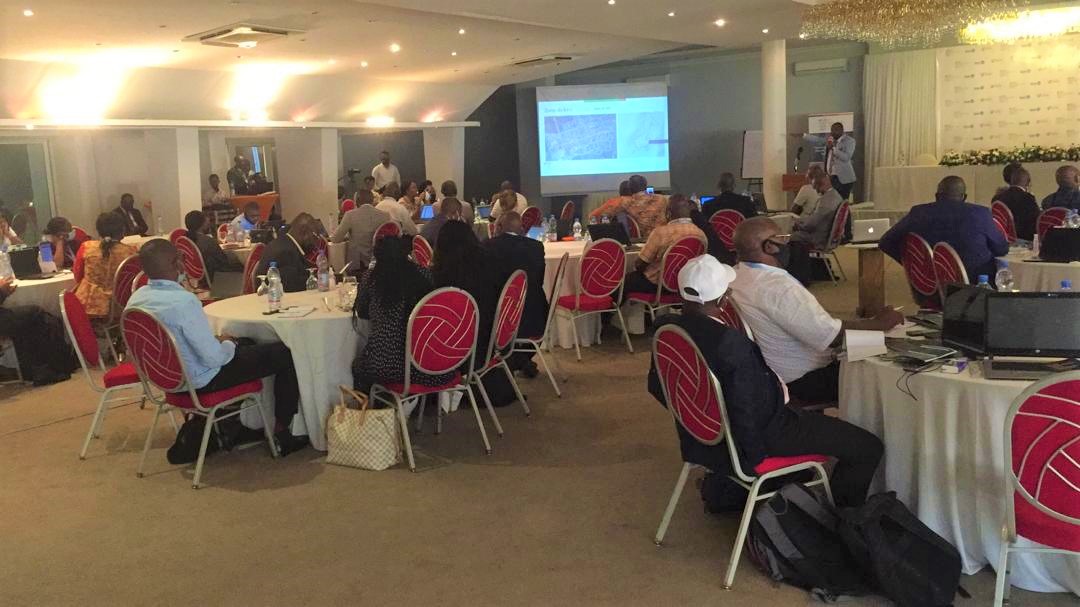
Cross section of participants at the GRID3 Mapping for Health event, ‘Towards digital microplanning: a forum on new geospatial and equity solutions for vaccination planning’ held in Kinshasa from 22-25 November.

Left to Right: Emmanuel Rukengwa, National Coordinator, GRID3 DRC; Dr Dieudonnée Mwamba Ilunga, Director, General Directorate for Disease Control, Dr Aimé Cikomola, Deputy Director, EPI, attending the forum.
Mapping for Health in DRC aims to strengthen the effectiveness and equity of vaccination interventions in the Democratic Republic of the Congo. It is building on DRC’s impressive strides over the last two decades in this domain, while intensifying and fast-tracking efforts to improve further. Mapping for Health in DRC is a Ministry of Health initiative delivered in partnership with Flowminder and the Center for International Earth Science Information Network at Columbia University (CIESIN), and in collaboration with WorldPop at the University of Southampton, Kinshasa School of Public Health, UNFPA, the World Food Programme, and UNOPS. Mapping for Health in DRC is a continuation of previous work conducted and/or supported in DRC by GRID3.
