New datasets and basemaps to strengthen health service delivery in five DRC provinces
As part of the GRID3 Mapping for Health project, five new GRID3 datasets (settlements, health area catchment boundaries, health facilities, schools, and religious centres) have been published for the provinces of Haut-Katanga, Kinshasa, Kasaï, Kasaï-Oriental, Kinshasa, and Lomami in the Democratic Republic of the Congo (DRC). These datasets, along with basemaps that overlay and visualise the data, will be included in the DRC’s national health database and, together with GRID3 DRC population estimates, have informed planning, delivery and surveillance of routine immunisations.
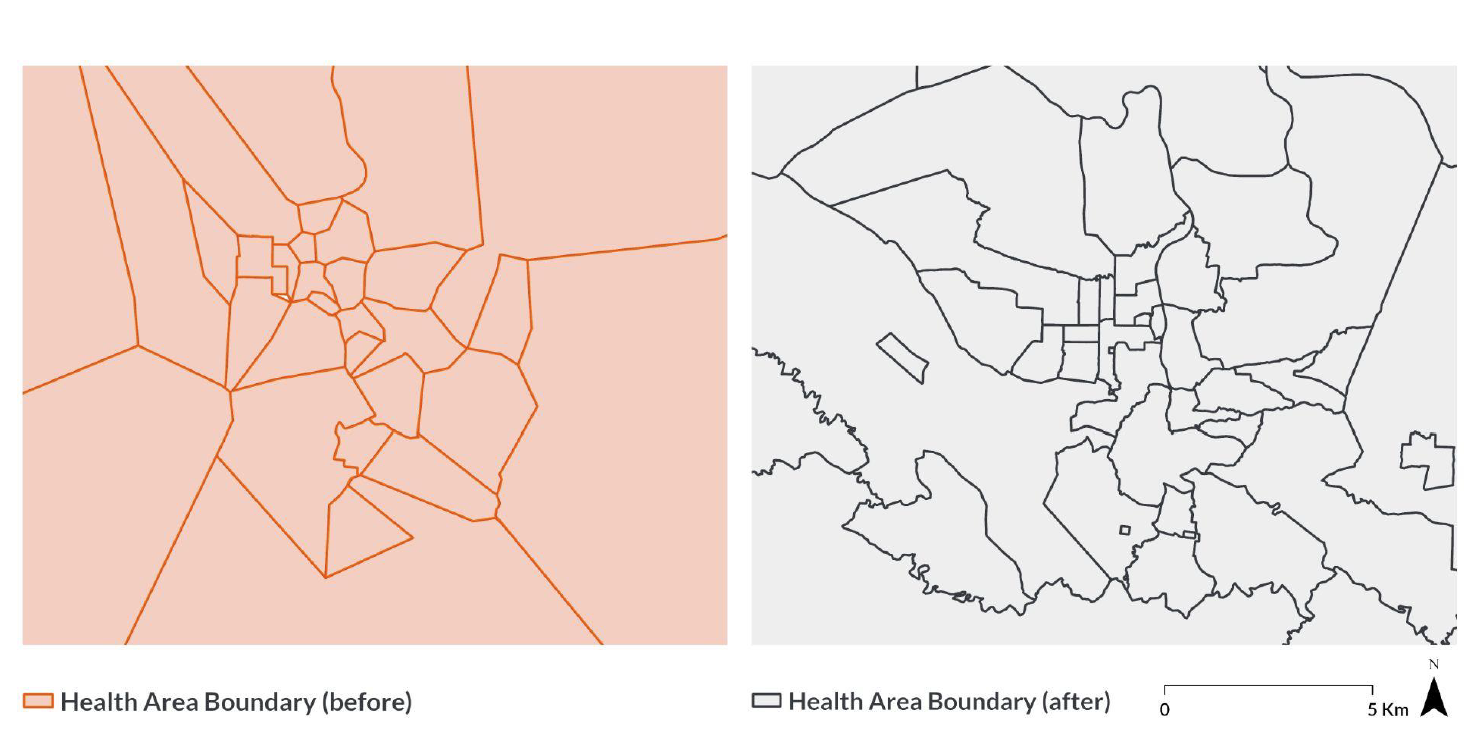
Improved health area boundaries in Likasi, Haut-Katanga Province
Creating the datasets was no small feat. As a first step, the GRID3 team held a series of meetings in late 2020 with DRC’s Expanded Program on Immunization (EPI).
“We learnt from the EPI that, while some data on health facilities, settlements, and boundaries were available, they came from different sources and were not consolidated. The data also did not provide the level of detail needed to really support their planning for health interventions,”
says Kevin Tschirhart, GRID3 DRC Country Lead.
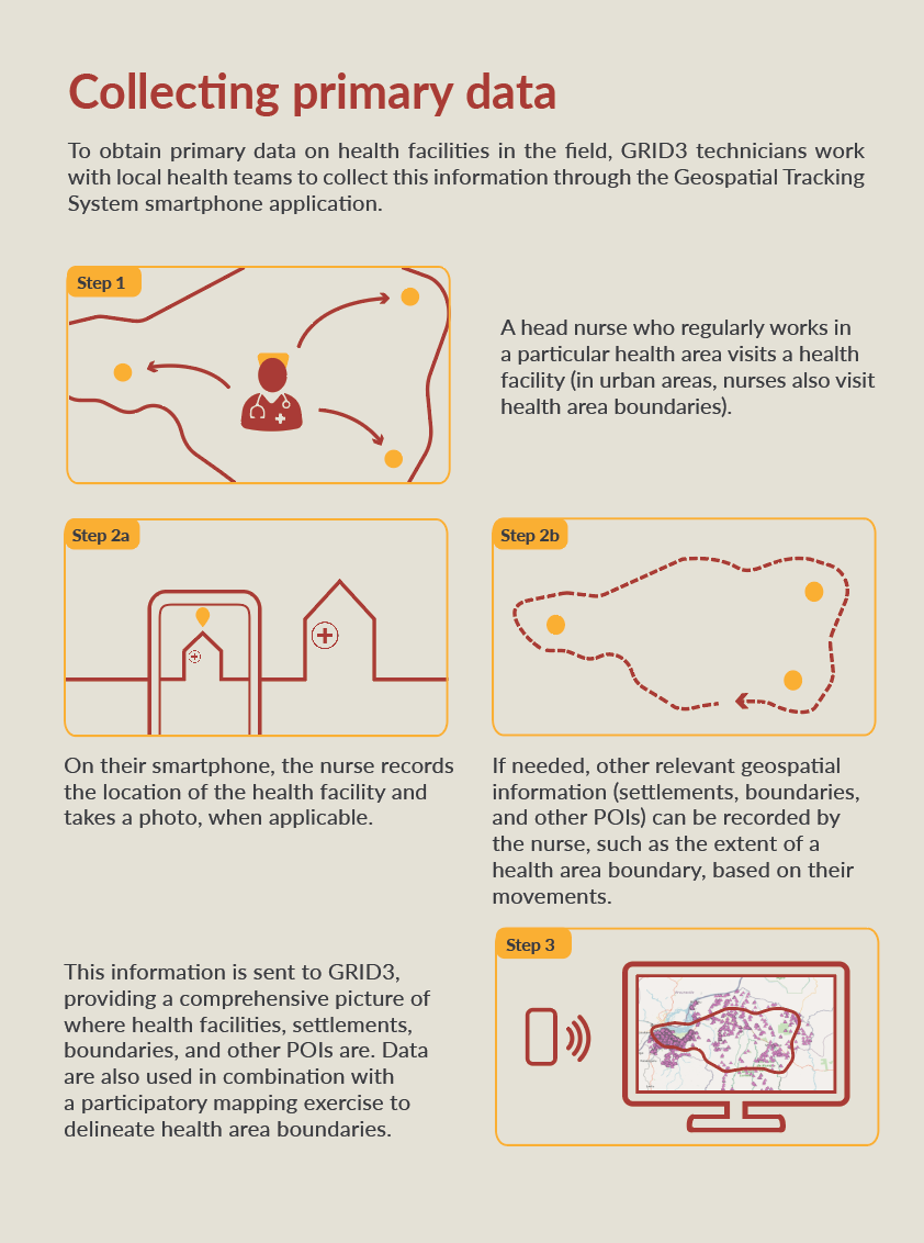
After these initial meetings, the team planned and completed a major data collection project between January and October 2021. GRID3 recruited and trained 24 local GIS mappers and 3 local coordinators to lead this effort. Working together with national and provincial health authorities, the GRID3 team collected geospatial data on settlements, health area catchment boundaries, health facilities, schools, and religious centres through a participatory mapping process. This involved deploying the mappers to health zones who trained head nurses in each health area on data collection using the Geospatial Tracking System (GTS), an ODK-based smartphone application developed by Novel-T. While the head nurses collected data in their respective health areas, mappers worked with each health zone’s management team to validate and modify health area boundaries using high resolution satellite imagery. Once the data were collected, cleaned, and integrated into geospatial layers, a first round of validation was conducted by the head doctor of each health zone.
“Despite challenges related to COVID-19 and the complex logistics of carrying out fieldwork in hard-to-reach communities (which comprise much of the DRC), we were able to collect high-quality, strategic GIS health data in over 1,800 health areas and train more than 500 health staff on data collection and GIS tools,”
says Emmanuel Rukengwa, GRID3 DRC National Coordinator.
“These comprehensive, strategic data will help us to produce a better denominator for the children who are in need of vaccination planning, which in turn will aid us in our effort to cover all children in these campaigns and, more generally, to strengthen the health system nationwide.”
After validation, the GRID3 team began an extensive data cleaning operation involving the removal of duplicate data, the identification of missing data, and the correction of errors by working with health zone management staff. The data were then used to produce printable basemaps at the health area level that were shared with every health zone and province for a second round of validation by EPI’s data managers and the head doctors of each health zone. The local health teams provided feedback on the maps that were meticulously integrated into the basemaps GIS layers by the GRID3 team. By February 2022, the EPI and the GRID3 Mapping for Health project’s Technical Committee conducted a final review of the maps and datasets, and corrections were made within the geodatabase.
To access and download the five new GRID3 datasets, please visit our Data Hub.
Collecting data in the field using the GTS smartphone application
GRID3 Mapping for Health in DRC, was an project implemented between 2020-2022, with the aim to strengthen the effectiveness and equity of vaccination interventions in the Democratic Republic of the Congo. It built on DRC’s impressive strides over the last two decades in this domain, while intensifying and fast-tracking efforts to improve further. GRID3 Mapping for Health was a Ministry of Health initiative delivered in partnership with Flowminder and the Center for International Earth Science Information Network at Columbia University (CIESIN), and in collaboration with WorldPop at the University of Southampton, Kinshasa School of Public Health, UNFPA, the World Food Programme, and UNOPS.
Beyond the Mapping for Health project, GRID3 is continuing to support the DRC government and other stakeholders in using core spatial data for improved health outcomes.
