Mapping settlement extents to support COVID-19 response efforts
Knowing the geographic areal coverage, or extent, of a settlement is key to mapping where people live. Mapping settlements allows for effective health interventions, enabling policymakers to identify areas that lack infrastructure (like clinics or testing centres) as well as vulnerable populations.
Many sub-Saharan African countries lack maps with this degree of detail, and GRID3 has a long track record of mapping settlements in the region to support health campaigns. Prior to the COVID-19 crisis, GRID3 had already been working with the Bill & Melinda Gates Foundation to map extents in 12 countries (supporting, among other things, planning for polio vaccination campaigns). That work has been fast-tracked for COVID-19 response. Using building footprint data extracted from Ecopia Landbase Africa powered by Maxar, GRID3 has prioritised mapping extents for several dozen more African countries over the next two months; by the end of April, extents will have been created for an additional 8 countries, and by the end of May another 17 will be completed, bringing the total countries covered to 37. With this expanded data in hand, policymakers and health officials will be able to plan a more effective COVID-19 response.
To download settlement extents for various countries, you can access here or through Columbia Academic Commons.
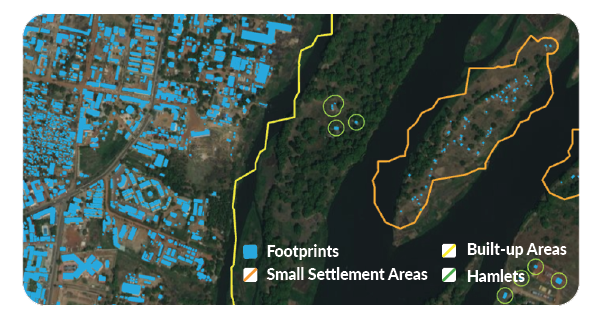
Settlement Extent: CIESIN, Columbia University under the GRID3 programme; Building Footprint: Ecopia Landbase Africa powered by Maxar; Image: Esri
Featured photo credit: © 2020 Maxar Technologies, © OpenStreetMap contributors (2020) (openstreetmap.org)
