Puntland Statistics Department, Somalia, leads the way in using geospatial data for crisis response and recovery
On 22 November 2020, Tropical Cyclone Gati made landfall on the Puntland State of Somalia’s coast. Drawing on new skills and techniques acquired during a series of GRID3 capacity strengthening sessions, the Puntland Statistics Department used geospatial data to effectively coordinate the state’s disaster response.
The partnership between Somalia’s National Bureau of Statistics (NBS), including the Puntland Statistics Department (PSD), and GRID3 began when these government bodies requested support in accessing and using high-resolution demographic and infrastructure data in their COVID-19 response. Seeing how central data was to these efforts, NBS and PSD have since made rapid mapping and high-resolution imagery a cornerstone of their subsequent crisis response efforts; Geographic Information Systems (GIS) and satellite maps are now used to support the efforts in containing the spread of the virus.
With this success in mind, the Global Partnership for Sustainable Development Data (GPSDD) and United Nations Economic Commission for Africa (UNECA), through the COVID-19: Data for a Resilient Africa initiative, facilitated more opportunities for these three bodies to cooperate. Over a two-month period, GRID3 provided a comprehensive virtual training and certification course for statistics officers from NBS and PSD in Mogadishu and Puntland on spatial analysis of gridded population data in ArcGIS, a GIS software programme. The workshops equipped each organisation with newly acquired geospatial tools and capabilities, such as producing a data visualisation hub, that could support the country’s COVID-19 decision-making. The newly acquired tools and skills also proved extremely crucial in the state’s response to Cyclone Gati.
On 22 November 2020, PSD officials successfully completed its series of GRID3 capacity strengthening sessions and had begun using GIS skills and tools to finalise a report, analysing the results of the region’s first-ever Health and Demographic Survey (DHS). National and regional statistics teams have been unable to produce reliable population data due to the country’s highly mobile population; half of the population is nomadic or semi-nomadic, and high insecurity and extreme weather have led to internal displacement.
On the same day, Cyclone Gati, an unprecedented storm in Somalia, with maximum sustained winds of 170 km/h, hit the coast of Puntland. To coordinate a data-informed emergency response, the department used tools from GRID3’s virtual training to monitor the cyclone and assess its impact. As a first step, PSD combined UNFPA Somalia’s 2014 Puntland Population Estimation Survey data with its DHS findings to overcome the lack of comprehensive state-wide population data. PSD then used satellite imagery to map the cyclone’s path and magnitude using data from the Joint Typhoon Warning Center (JTWC). Subsequently, they identified the location of villages and critical infrastructure such as roads, schools, and health clinics within Gati’s trajectory. By triangulating these various data, PSD was able to estimate that approximately 10,000 households (60,000 people) lived in the worst-affected areas of Bosaso, Hafun, and Qandala districts. Overall, nearly 180,000 people lost their livelihoods, shelter, and other basic resources (leading analysts to estimate that an additional 42,000 were displaced).
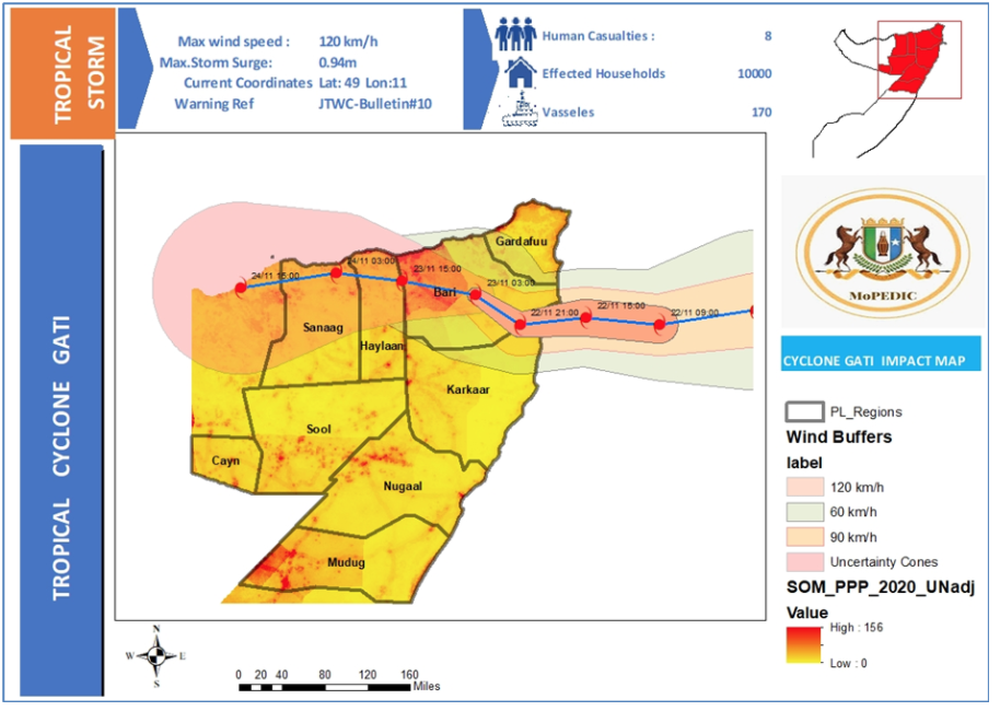
Cyclone Gati impact map, produced by Puntland Department Office
Coordinating a data-driven response
To facilitate integrated interagency relief efforts, the President of Puntland State appointed a High-Level Cabinet Coordination Team (HLCCT), which included representatives from various ministries such as the Office of the Vice President and the Ministry of Planning, Economic Development and International Cooperation.
PSD presented their analysis to the HLCCT to help determine an appropriate course of action. The HLCCT aimed to use the findings to consider the effects of the cyclone on food security and infrastructure in the region. Using the information provided, the response coordination team was able to assess where impacts were greatest, and to locate damaged buildings or injured residents.
“With the support of GIS tools and skills training, we were able to determine in real-time the cyclone-affected areas and intensity levels, as well as extract key disaster information about affected points of interest such as hospitals and schools, cropland, flooding, and so on. Without this information, the Government of Puntland would not have been able to anticipate and rapidly make targeted responses to the damage caused by Gati. In the same vein, a targeted COVID-19 response relies on the same skill sets and datasets,”
concludes Abdifatah Mohamed, Director at Puntland Statistics Department.
Somalia National Bureau of Statistics and GRID3 will continue their collaboration in the coming months by expanding these skills nationally.
This article was co-written by GRID3, Abdirisak Aden and Abdullahi Kelly from Puntland Statistics Department, and Muthoni Mugo from Global Partnership for Sustainable Development Data (GPSDD).
Featured photo credit: Yusuf Som, Flickr; Cyclone Gati satellite imagery: NASA, Wikimedia Commons
