Physical distancing datasets can help control COVID-19 spread in sub-Saharan Africa’s urban areas
GRID3 has released 50 new datasets that can support countries looking to use nuanced, data-driven approaches in controlling the spread of the novel coronavirus. These data provide information on urban areas in sub-Saharan Africa where population density and the spatial arrangement of buildings may make it difficult to maintain physical distancing (also known as “social distancing”).
“This information can be used by public health officials to identify where there is potential for rapid spread, and where additional measures may be needed to limit the spread of the virus. It may also be beneficial as an advocacy tool for communities in affected areas, as it provides evidence of the difficulties they face in complying with COVID-19 restrictions,“ explains Heather Chamberlain, a GRID3 expert who worked on the datasets.
To ensure these data can be widely used, GRID3 will be developing interactive maps that enable public health officials to perform relevant analyses critical for COVID-19-focused interventions, such as planning for vaccination campaigns. The data will also be shared with stakeholders who can use the information to plan for and respond to coronavirus outbreaks.
Designing the data
Initially, GRID3 experts developed this data specifically for Lusaka, Zambia; Deutsche Gesellschaft für Internationale Zusammenarbeit expressed a need for this type of information to improve its COVID-19 response and prevention strategies. Similar data were then generated for Nakonde, Zambia, following a COVID-19 outbreak. Due to wider interest, this work was scaled up to cover urban areas throughout sub-Saharan Africa.
To produce the datasets, GRID3 experts used high-resolution geospatial data that provide granular insights into the likely space available around buildings and estimated population density. These data took the form of building footprint polygons (from Ecopia.AI, powered by Maxar) that displayed an outline of each building and gridded population datasets from WorldPop (WorldPop Global and GRID3 datasets) that have an estimated population count for each 100 x 100 metre grid cell. These data were classified to create a population and building score, from which an index value was calculated. Areas with higher index values indicate greater difficulty in practicing physical distancing among individuals while areas with lower index values have less difficulty. GRID3 experts then calculated the physical distancing risk for areas bounded by features such as roads or rivers.
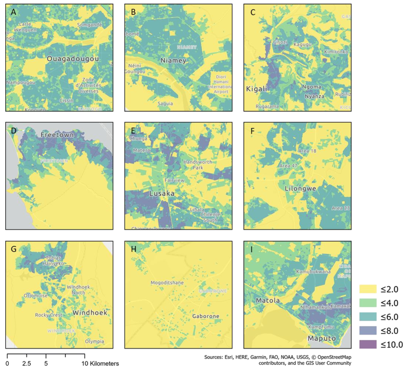
Snapshots of major urban areas in sub-Saharan Africa. Darker colors symbolise areas that have higher levels of difficulty in maintaining physical distancing conventions.
(From top left – Ouagadougou, Burkina Faso; Niamey, Niger; Kigali, Rwanda; Freetown, Sierra Leone; Lusaka, Zambia; Lilongwe, Malawi; Windhoek, Namibia; Gaborone, Botswana; Maputo, Mozambique)
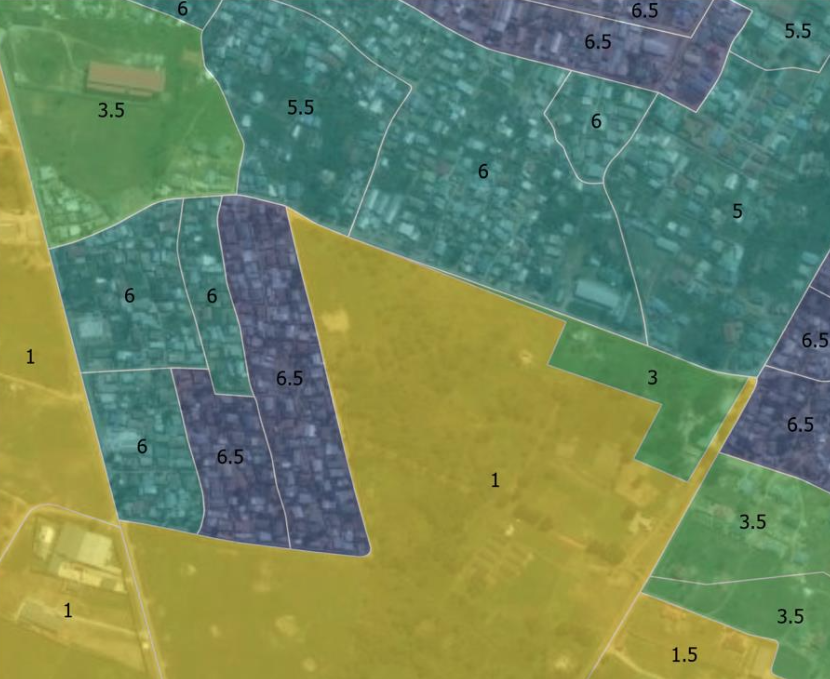
The image above showcases ease of social distancing index values for an area in the west of Lusaka, Zambia. The index values for spatial units are shown overlain on satellite imagery. Higher values indicate greater difficulty in physical distancing.
“Our approach is unique because we use both the arrangement of buildings and estimated population density to assess where there may be difficulties in physical distancing. Other analyses that look at this phenomenon are based on, for example, pavement widths. Such approaches are however limited due to their reliance on detailed data on specific infrastructure features that are typically only available for selected areas in some high-income countries. Having access to data on building footprints has meant we’ve been able to develop and apply our approach more widely,” says Chamberlain.
To access the datasets, please visit our Data page. For questions, please visit our Contact Us page.
