Modelled population estimates for census under-coverage make Burkina Faso’s population visible in times of conflict
GRID3 has produced datasets featuring high-resolution modelled population estimates and maps to complement Burkina Faso’s 2019 census results. The approach the GRID3 Burkina Faso team took to generate the estimates introduces an innovative method of estimating population for the country by leveraging the power of geospatial data and satellite imagery.
To ensure maximum completeness of Burkina Faso’s 2019 census, the GRID3 Burkina Faso team produced high-resolution modelled population estimates disaggregated by age and sex for 20%, or 5,620,429 hectares, of the country’s territory. Enumeration in these areas was not possible partly due to security issues. The estimates led to the inclusion of 2,098,645 people into Burkina Faso’s census. Where insecurity, disease, and remoteness make universal enumeration impossible, GRID3’s methods can be applied in any country.
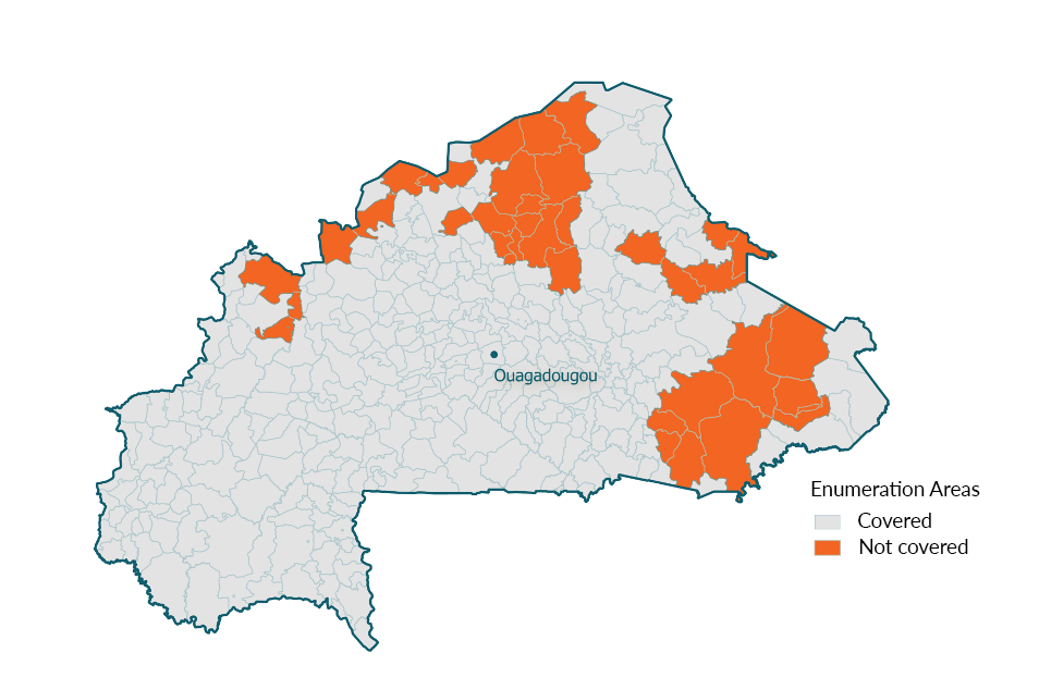
This map demonstrates what areas were covered/counted from census enumeration. Insecurity prevented census enumerators from reaching certain areas.
The datasets, along with maps, complement the Government of Burkina Faso’s census results, guaranteeing an accurate picture of Burkina Faso’s population. To continue the “data” momentum, the GRID3 Burkina Faso team are organising capacity strengthening activities that enable key stakeholders to use the data and the modelling approach to inform decision-making and future surveys, ensuring their integration into regular planning and decision-making practices.
Orchestrating the 2019 census
The census is Burkina Faso’s biggest and most complex effort to collect population data. Between December 2019 and January 2020, more than 20,000 enumerators spread out into remote and non-remote areas to count Burkina Faso’s population, canvassing households, collecting individual information, and compiling millions of completed questionnaires.
Before the exercise, INSD Burkina Faso (Institut National de la Statistique et de la Démographie – the National Statistics Office of Burkina Faso) was able to cover more areas than initially expected by taking a community-centred approach: as part of the cartography stage, where the whole country is mapped in preparation for census enumeration, INSD successfully trained local people from hard-to-reach areas to conduct enumeration. Their inclusion in the enumeration workforce increased access to these areas.
At the end of the exercise, the government amassed a wealth of data that included numbers of people and information on their spatial distribution, age and sex structure, living conditions and other key socioeconomic characteristics. This information is critical for good governance, policy formulation, development planning, risk reduction, crisis response, social welfare programmes and business market analyses, among other applications.
Despite the enormous efforts and measures taken to expand coverage, enumeration in certain areas of Burkina Faso still turned out to be impossible due to insecurity. To ensure that no one is left behind, the GRID3 Burkina Faso team produced modelled population estimates for the uncovered areas.
“Burkina Faso’s 2019 census has been a great success. INSD and partners were able to guarantee more coverage than expected. While GRID3’s modelled population estimates are not census data, we are very pleased that the alliance with GRID3 gave us the opportunity to combine their findings with the data we collected from our recent census. The availability of this data will allow us to implement national programs and policies better tailored to the socio-economic needs of the people of Burkina Faso,”
says Hervé Bassinga, research officer in demographics at INSD.
How the estimates were produced
To produce the modelled population estimates, the GRID3 Burkina Faso team worked with INSD to identify covered and uncovered areas from census enumeration fieldwork.
The approach the GRID3 Burkina Faso team took to generate the estimates introduces an innovative method of estimating population for the country by leveraging the power of geospatial data and satellite imagery.
“After analysing and cleaning the data, we incorporated the recently collected census data into a statistical model, using the Bayesian bottom-up modelling approach. This method allowed us to produce gridded population estimates for the whole country, from existing and newly collected census data. Census data contain GPS locations of households and are combined with boundary and satellite-derived data such as settlements, elevation, slope and vegetation. The model then estimates population counts in unsurveyed zones by extracting information from similar areas across the country. This method provides countries with the finest data possible, namely 100-metre gridded estimates,”
explains Édith Darin, a GRID3 modeller working on the estimates.
To access the Burkina Faso estimates, please visit our Data Hub.
Featured photo credit: Jeff Attaway, Wikimedia
